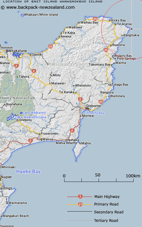
Map showing location of East Island (Whangaokeno Island)


LINZ description: Small island located approximately 2.2km due east of East Cape. Feature shown on: NZMS260 Z14; NZTopo50-BD45 918138.
Latitude: -37.691694
Longitude: 178.576056
Northing: 5813733.1
Easting: 2091802.3
Land District: Gisborne
Feat Type: Island


Scroll down to see a more detailed road map and below that a topographical map showing the location of East Island (Whangaokeno Island). The road map has been supplied by openstreetmap and the topographical map of East Island (Whangaokeno Island) has been supplied by Land Information New Zealand (LINZ).

Yes you can use the top static map for you school/university project or personal website with a link back. Contact me for any commercial use.

East Island (Whangaokeno Island) Map New Zealand


New Zealand places in our database
[ A ] [ B ] [ C ] [ D ] [ E ] [ F ] [ G ] [ H ] [ I ] [ J ] [ K ] [ L ] [ M ] [ N ] [ O ] [ P ] [ Q ] [ R ] [ S ] [ T ] [ U ] [ V ] [ W ] [ X ] [ Y ] [ Z ]


Closest 20 Islands to East Island (Whangaokeno Island)

Moutahiauru Island ( 45.28km )   Motuaiuri Island ( 45.91km )   Otarawhata Island ( 55.13km )   Motuhina Island ( 61.25km )   Motuoroi Island ( 65.51km )   Motu Kaimeanui Island ( 68.48km )   Motu Papaka Islands ( 68.98km )   Motu Papaku Islands ( 68.98km )   Te Huka Island ( 72.41km )   Motukotare Island ( 75.04km )   Mitre Rocks ( 78.77km )   Pourewa Island ( 79.56km )   Motunui Island ( 82.23km )   Gable Islet ( 96.82km )   Whangara Island ( 102.42km )   Tuamotu Island ( 121.85km )   Club Rock ( 123.71km )   Whakaari/White Island ( 124.09km )   Whakaari Island ( 124.09km )   Whangakopikopiko Island ( 130.02km )   Patawa Island ( 131.32km )   Pataua Island ( 131.32km )   Motuotu Island ( 131.58km )   Hokianga Island ( 131.75km )   Uretara Island ( 132.27km )   Ohakana Island ( 135.44km )   Moutohora Island ( 142.05km )   Motuhora ( 142.05km )   Moutoki Island ( 149.57km )   Rurima Island ( 150.58km )   Tokata Island ( 151.3km )   Rahui Island ( 166.61km )   Te Oneatahu Island ( 166.64km )   Te Kahaatuwai Island ( 167.35km )   Te Arakoau Island ( 167.87km )   Motungarara Island ( 167.9km )   Motutorutoru Island ( 168.33km )   Plate Island ( 177.47km )   Motunau (Plate Island) ( 177.47km )   Motuhaku Island (Schooner Rocks) ( 180.7km )