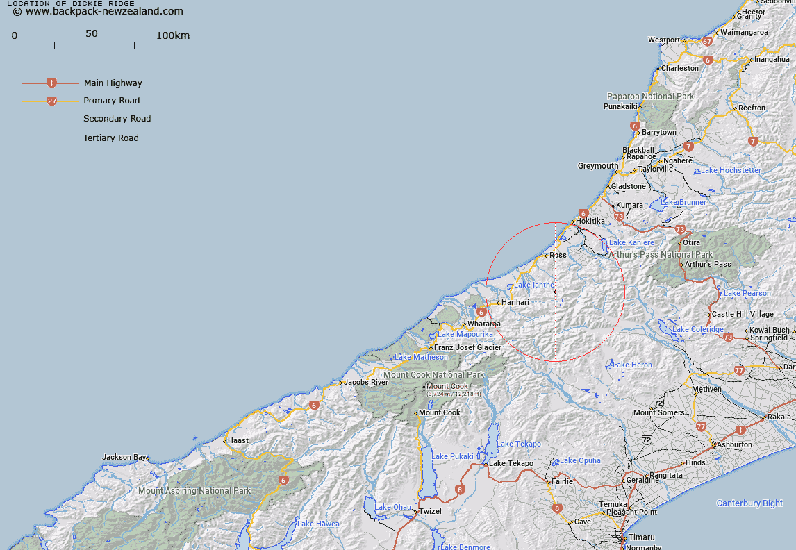
Map showing location of Dickie Ridge


LINZ description: For the lower part of the Dickie ridge which forms the divide between the Tuke and Kakapotahi Rivers
Latitude: -43.089724
Longitude: 170.868235
Northing: 5227015.9
Easting: 1426493.6
Land District: Westland
Feat Type: Ridge


Scroll down to see a more detailed road map and below that a topographical map showing the location of Dickie Ridge. The road map has been supplied by openstreetmap and the topographical map of Dickie Ridge has been supplied by Land Information New Zealand (LINZ).

Yes you can use the top static map for you school/university project or personal website with a link back. Contact me for any commercial use.

Dickie Ridge Map New Zealand


New Zealand places in our database
[ A ] [ B ] [ C ] [ D ] [ E ] [ F ] [ G ] [ H ] [ I ] [ J ] [ K ] [ L ] [ M ] [ N ] [ O ] [ P ] [ Q ] [ R ] [ S ] [ T ] [ U ] [ V ] [ W ] [ X ] [ Y ] [ Z ]


Closest 20 Ridges to Dickie Ridge

Sawtooth Ridge ( 3.35km )   Galena Ridge ( 4.61km )   Swandri Spur ( 5.3km )   Harker Spur ( 6.6km )   Clearview Spur ( 7.19km )   Steadman Brow ( 7.78km )   Mikonui Spur ( 9.1km )   Headlong Spur ( 9.29km )   Pahlow Ridge ( 10.18km )   Scramble Spur ( 10.71km )   Cropp Brow ( 10.85km )   Notch Ridge ( 11.29km )   Misty Ridge ( 12.09km )   Carl Spur ( 12.41km )   Whirlwind Spur ( 12.56km )   Miserable Ridge ( 13.02km )   Katzenbach Ridge ( 13.9km )   Chink Ridge ( 14.62km )   Mazda Spur ( 14.62km )   Crumbling Spur ( 14.67km )   Carls Ridge ( 15.52km )   Griffen Spur ( 15.66km )   Peter Spur ( 16.14km )   Karnbach ( 16.58km )   Karnback ( 16.58km )   Ford Ridge ( 16.72km )   Knobby Ridge ( 17.35km )   Terra Quinn ( 17.36km )   Malfroy Spur ( 17.39km )   Harold Spur ( 17.59km )   Slippery Brae ( 18.3km )   Caulfield Spur ( 18.62km )   Gerhardt Spur ( 19.79km )   Conway Ridge ( 20.55km )   Max Spur ( 22.54km )   Treachery Ridge ( 22.65km )   Homeward Ridge ( 23.4km )   Long Spur ( 23.92km )   Table Spur ( 24.76km )   Secretary Ridge ( 25.69km )