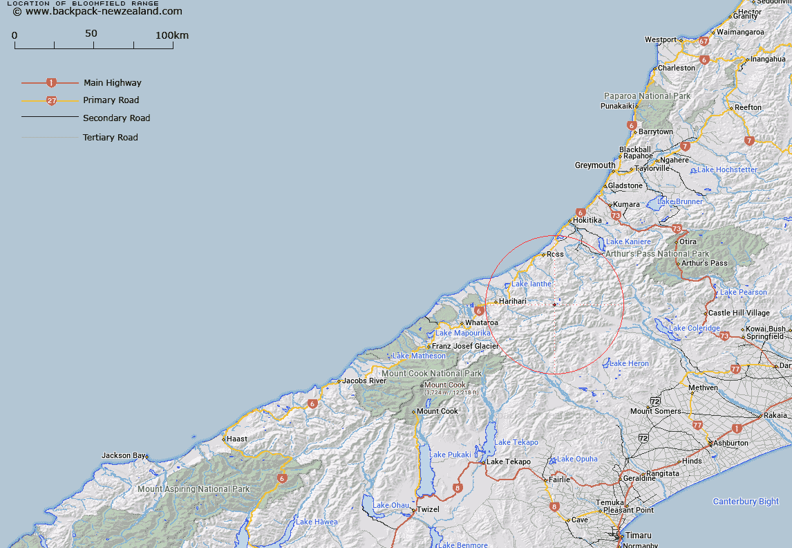
Map showing location of Bloomfield Range


LINZ description: A mountain range extending northwest for approximately 6.5km from spot height 2215m north of McKenzie Col, through Artist Dome and Mount Blomfield, to a point southwest of the headwaters of Waitaha River. NZTopo50-BW18 306180 to 260214.
Latitude: -43.164353
Longitude: 170.880255
Northing: 5218752.7
Easting: 1427681.7
Land District: Westland
Feat Type: Range


Scroll down to see a more detailed road map and below that a topographical map showing the location of Bloomfield Range. The road map has been supplied by openstreetmap and the topographical map of Bloomfield Range has been supplied by Land Information New Zealand (LINZ).

Yes you can use the top static map for you school/university project or personal website with a link back. Contact me for any commercial use.

Bloomfield Range Map New Zealand


New Zealand places in our database
[ A ] [ B ] [ C ] [ D ] [ E ] [ F ] [ G ] [ H ] [ I ] [ J ] [ K ] [ L ] [ M ] [ N ] [ O ] [ P ] [ Q ] [ R ] [ S ] [ T ] [ U ] [ V ] [ W ] [ X ] [ Y ] [ Z ]


Closest 20 Ranges to Bloomfield Range

Blomfield Range ( 0km )   Bloomfield Range ( 0km )   Lange Range ( 5.41km )   Mitchin Range ( 7.41km )   Hitchin Range ( 7.41km )   Smyth Range ( 9.17km )   Butler Range ( 9.18km )   Lord Range ( 9.98km )   Purcell Range ( 14.86km )   Ragged Range ( 17.76km )   Speculation Range ( 18.21km )   Bonar Range ( 18.99km )   Agassiz Range ( 19.18km )   Froude Range ( 19.54km )   Jollie Range ( 20.19km )   Armoury Range ( 20.23km )   Bald Hill Range ( 20.36km )   Rangitoto Range ( 20.37km )   Meta Range ( 20.92km )   Wilberg Range ( 22.73km )   Willberg Range ( 22.73km )   Arrowsmith Range ( 23.04km )   Diedrichs Range ( 25.29km )   Diedrich Range ( 25.29km )   Rolleston Range ( 27.19km )   Wild Mans Brother Range ( 27.89km )   Cloudy Peak Range ( 30.45km )   Southern Alps/K? Tiritiri o te Moana ( 30.47km )   Southern Alps ( 30.47km )   Potts Range ( 30.55km )   Adams Range ( 30.57km )   Cascade Range ( 32.47km )   Toaroha Range ( 33.3km )   Big Hill Range ( 33.94km )   Palmer Range ( 34.71km )   Browning Range ( 39.47km )   Two Thumb Range ( 39.74km )   Dogs Range ( 40.79km )   Butler Range ( 40.85km )   Birdwood Range ( 43.29km )