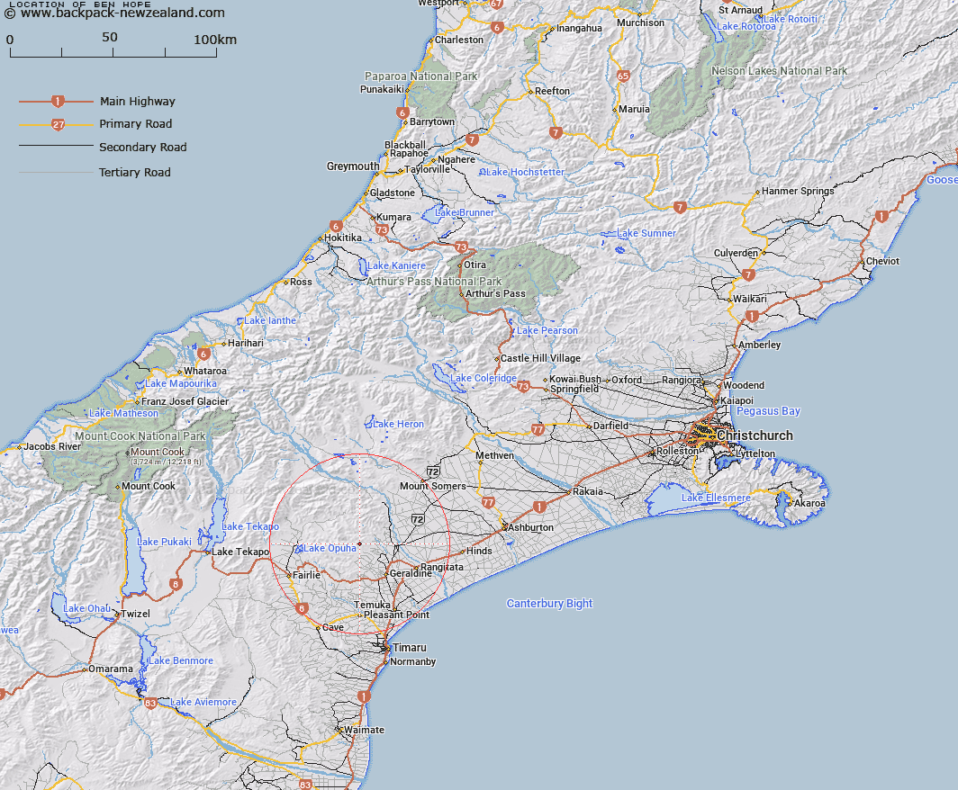
Map showing location of Ben Hope


LINZ description: Hill (1034m) at the head of Station Stream, with Trig. X (Geodetic Code AMVG) on the summit. Block XII Four Peaks Survey District.
Latitude: -43.966977
Longitude: 171.131296
Northing: 5130097.5
Easting: 1450094.2
Land District: Canterbury
Feat Type: Hill


Scroll down to see a more detailed road map and below that a topographical map showing the location of Ben Hope. The road map has been supplied by openstreetmap and the topographical map of Ben Hope has been supplied by Land Information New Zealand (LINZ).

Yes you can use the top static map for you school/university project or personal website with a link back. Contact me for any commercial use.

Ben Hope Map New Zealand


New Zealand places in our database
[ A ] [ B ] [ C ] [ D ] [ E ] [ F ] [ G ] [ H ] [ I ] [ J ] [ K ] [ L ] [ M ] [ N ] [ O ] [ P ] [ Q ] [ R ] [ S ] [ T ] [ U ] [ V ] [ W ] [ X ] [ Y ] [ Z ]


Closest 20 Hills to Ben Hope

Mount Frances ( 6.39km )   Waihi Peak ( 6.83km )   Tripps Peak ( 7.14km )   Mount Edith ( 8.23km )   Blue Mountain ( 8.76km )   Fiery Peak ( 9.29km )   Devils Peak ( 10.48km )   Little Mount Peel/Huatekerekere ( 11.57km )   Little Mount Peel ( 11.57km )   Grants Top ( 11.64km )   Mount Catherine ( 12.21km )   Middle Mount Peel ( 12.41km )   Mount Walker ( 12.78km )   Mount Peel ( 13.55km )   Waitohi Hill ( 13.99km )   Round Hill ( 15.37km )   Sugar Loaf ( 17.79km )   Kakahu Hill ( 19.44km )   Coal Hill ( 20.88km )   Mount Michael ( 22.46km )   Mount Pukanui ( 25.94km )   Low Hills ( 28.42km )   Mount Gay ( 28.44km )   Ben McLeod ( 29.32km )   Rawtor ( 30.54km )   Mount Tripp ( 30.97km )   Fox Peak ( 31.36km )   Cairn Hill ( 32.77km )   The Brothers ( 33.47km )   Mount Possession ( 34.31km )   Sugar Loaf ( 34.6km )   Mount Harper/Mahaanui ( 34.94km )   Mount Harper ( 34.94km )   Mount Misery ( 35.68km )   Woolmer Hill ( 35.98km )   Sandys Knob ( 36.02km )   Neutral Hill ( 36.33km )   High Terrace ( 36.66km )   Dobson Peak ( 37.1km )   Mount Musgrave ( 37.8km )