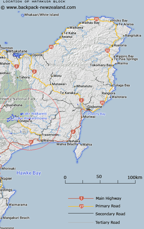
Map showing location of Matakuia Block


LINZ description: East of the Ngamoko Range east of Lake Waikaremoana
Latitude: -38.780654
Longitude: 177.269307
Northing: 5698900
Easting: 1970900
Land District: Gisborne
Feat Type: Appellation


Scroll down to see a more detailed road map and below that a topographical map showing the location of Matakuia Block. The road map has been supplied by openstreetmap and the topographical map of Matakuia Block has been supplied by Land Information New Zealand (LINZ).

Yes you can use the top static map for you school/university project or personal website with a link back. Contact me for any commercial use.

Matakuia Block Map New Zealand


New Zealand places in our database
[ A ] [ B ] [ C ] [ D ] [ E ] [ F ] [ G ] [ H ] [ I ] [ J ] [ K ] [ L ] [ M ] [ N ] [ O ] [ P ] [ Q ] [ R ] [ S ] [ T ] [ U ] [ V ] [ W ] [ X ] [ Y ] [ Z ]


Closest 20 Appellations to Matakuia Block

Tarapatiki Maori Block ( 12.12km )   Terapatiki Maori Block ( 12.12km )   Huramua Block ( 27.46km )   Hauruma Block ( 27.46km )   Poututu Rural Sections ( 30.87km )   Tuwatawata ( 39.45km )   Tuatawhata ( 39.45km )   Tuawatawata ( 39.45km )   Tarewaeru ( 42.64km )   Tarewauru Block ( 42.64km )   Tiro-o-Tane ( 47.04km )   Tiraotane Block ( 47.04km )   Oriwha ( 52.19km )   Orewha ( 52.19km )   Awa-o-totara Block ( 52.21km )   Waowaototara Block ( 52.21km )   Te Hahainga ( 56.54km )   Te Hahaenga Block ( 56.54km )   Poukokonga Block ( 56.63km )   Pokokonga ( 56.63km )   Whakapaupakahi ( 58.85km )   Whakapaupakihi ( 58.85km )   Aropaoanui Block ( 61.04km )   Arapaoanoi Block ( 61.04km )   Weao ( 63.69km )   Wheao Survey District ( 63.69km )   Waioeka Parish ( 81.95km )   Waiotahi Parish ( 83.41km )   Waiotahe Parish ( 83.41km )   Hawke's Bay Land District ( 83.67km )   Tutamoe Block ( 85.51km )   Tutamoi Block ( 85.51km )   Ngatira ( 87.16km )   Ngatiira ( 87.16km )   Matuatonga Block ( 92.78km )   Matatuotonga Block ( 92.78km )   Tutamoe Survey District ( 93.22km )   Tutamoi Survey District ( 93.22km )   Waiaua East Survey District ( 94.12km )   Waiawa East ( 94.12km )