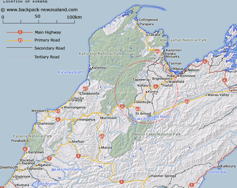
Map showing location of Korere


LINZ description: NZ Topo50 BR24 Trig 1196 at 664m height, west of Long Gully Stream and east of the Motupiko River.
Latitude: -41.528959
Longitude: 172.79263
Northing: 5402500
Easting: 1582700
Land District: Nelson
Feat Type: Trig Station


Scroll down to see a more detailed road map and below that a topographical map showing the location of Korere. The road map has been supplied by openstreetmap and the topographical map of Korere has been supplied by Land Information New Zealand (LINZ).

Yes you can use the top static map for you school/university project or personal website with a link back. Contact me for any commercial use.

Korere Map New Zealand


New Zealand places in our database
[ A ] [ B ] [ C ] [ D ] [ E ] [ F ] [ G ] [ H ] [ I ] [ J ] [ K ] [ L ] [ M ] [ N ] [ O ] [ P ] [ Q ] [ R ] [ S ] [ T ] [ U ] [ V ] [ W ] [ X ] [ Y ] [ Z ]


Closest 20 Trig Stations to Korere

Kohatu ( 9.14km )   Nestor ( 19.09km )   Dovedale ( 27.96km )   Tutaki ( 48.54km )   Haycock ( 53.52km )   Mount Pisgah ( 69.27km )   Murray Peak ( 69.27km )   Faerie Queene ( 84.92km )   McLarens ( 88.15km )   Matapehe ( 88.15km )   Dukeshead ( 91.45km )   Dumgree ( 100.69km )   Mount Saul ( 119.82km )   Flintoff ( 132.39km )   Flintoft ( 132.39km )   Pahau ( 141.01km )   Te Kopahou ( 161.21km )   Weka ( 164.79km )   Johnston Hill ( 164.8km )   Johnson Hill ( 164.8km )   Tawatawa ( 165.88km )   Vogeltown ( 166.77km )   Flag No. 2 ( 166.77km )   Witako ( 166.99km )   Etako ( 166.99km )   Flag No. 1 ( 168.06km )   Melrose ( 168.06km )   Rangoon Heights ( 170.4km )   Mount Misery ( 170.4km )   Ngauranga ( 171.65km )   Ngahauranga ( 171.65km )   Puketea ( 180.78km )   Pukeatea ( 180.78km )   Tuteremoana ( 193.08km )   Wainui (Whareroa) ( 193.3km )   Whareroa ( 193.3km )   Bawbaw ( 198.05km )   Mangaroa ( 198.12km )   Waiorongomai ( 199.59km )   Wairongoma ( 199.59km )