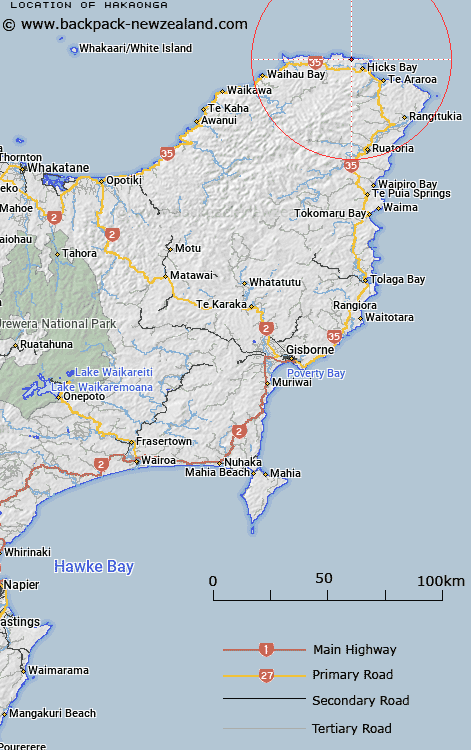
Map showing location of Hakaonga


LINZ description: 1.5km south-west of Hukanui Point, north of Wharekahika River. Feature shown on: NZMS260 Z14 Edition 1 1983
Latitude: -37.557622
Longitude: 178.248203
Northing: 5830300
Easting: 2063700
Land District: Gisborne
Feat Type: Hill


Scroll down to see a more detailed road map and below that a topographical map showing the location of Hakaonga. The road map has been supplied by openstreetmap and the topographical map of Hakaonga has been supplied by Land Information New Zealand (LINZ).

Yes you can use the top static map for you school/university project or personal website with a link back. Contact me for any commercial use.

Hakaonga Map New Zealand


New Zealand places in our database
[ A ] [ B ] [ C ] [ D ] [ E ] [ F ] [ G ] [ H ] [ I ] [ J ] [ K ] [ L ] [ M ] [ N ] [ O ] [ P ] [ Q ] [ R ] [ S ] [ T ] [ U ] [ V ] [ W ] [ X ] [ Y ] [ Z ]


Closest 20 Hills to Hakaonga

Hakaonga ( 0km )   Hakainga ( 0km )   Patangata ( 4.14km )   Te Koau ( 7.52km )   Pukeamaru ( 10.89km )   Te Pekaoterangihekeiho ( 13.59km )   Maungahiha ( 14.03km )   Ruahakoakoa ( 14.46km )   Mount Kokomuka ( 15.82km )   Mount Kokomuku ( 15.82km )   Te Kohe ( 17.9km )   Taumataorei ( 18.98km )   Mataraua ( 19.14km )   Te Kapua ( 19.68km )   Pukekaka ( 19.73km )   Taraketiti ( 20.03km )   Whakatiki ( 20.24km )   Ngatohuahira ( 20.43km )   The Watch Dog ( 21.68km )   Ngawhakatatara ( 21.72km )   Maungakaka ( 22.06km )   Rakitawhero ( 22.36km )   Tikirau ( 22.65km )   Whakaangiangi ( 22.67km )   Taumaoteawhengaiao ( 22.69km )   Tapuaeharuru ( 23.75km )   Wharikirauponga ( 23.97km )   Parahaki ( 24.29km )   Tipari ( 24.77km )   Raukumara ( 25.22km )   Tutaewhakapiki ( 25.38km )   Otarapaoa ( 27.26km )   Kokomukataranga ( 27.36km )   Mangairoa ( 27.49km )   Pakira ( 27.62km )   Aoparauri ( 27.92km )   Te Ranginui ( 28.48km )   Taumataomiro ( 28.51km )   Mangatutaekuri ( 28.56km )   Ouewheki ( 28.82km )