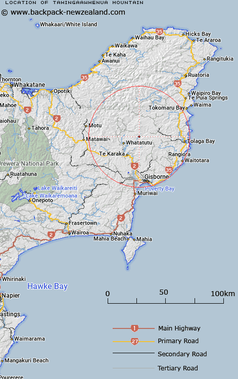
Map showing location of Tahingaawhenua Mountain


LINZ description: 16km north-east from Te Karaka (locality). Height: 285m
Latitude: -38.335617
Longitude: 177.957618
Northing: 5745300
Easting: 2033400
Land District: Gisborne
Feat Type: Hill


Scroll down to see a more detailed road map and below that a topographical map showing the location of Tahingaawhenua Mountain. The road map has been supplied by openstreetmap and the topographical map of Tahingaawhenua Mountain has been supplied by Land Information New Zealand (LINZ).

Yes you can use the top static map for you school/university project or personal website with a link back. Contact me for any commercial use.

Tahingaawhenua Mountain Map New Zealand


New Zealand places in our database
[ A ] [ B ] [ C ] [ D ] [ E ] [ F ] [ G ] [ H ] [ I ] [ J ] [ K ] [ L ] [ M ] [ N ] [ O ] [ P ] [ Q ] [ R ] [ S ] [ T ] [ U ] [ V ] [ W ] [ X ] [ Y ] [ Z ]


Closest 20 Hills to Tahingaawhenua Mountain

Toromiro ( 3.75km )   Pyramid ( 5.35km )   Arakihi ( 8.16km )   Pukerua ( 8.51km )   Rangirewa ( 9.81km )   Ruamaere ( 10.11km )   Ahioteatua ( 10.89km )   Paraheka ( 11.41km )   Tatai ( 11.5km )   Rangatira ( 11.92km )   Wheturau ( 12.68km )   Ahititi ( 13km )   Rakaukaka ( 13.46km )   Te Rimu ( 14.33km )   Pukenohi ( 14.53km )   Ngauotekaka ( 14.98km )   Makiri ( 15.74km )   Kiorekaitarahore ( 16.27km )   Kaiwinika ( 16.33km )   Pukenene ( 17.29km )   Kainaonao ( 18.65km )   Pukematai ( 18.72km )   Tirohanga ( 18.72km )   Te Kapua ( 18.77km )   Rakurakutara ( 19.3km )   Mangamaunu ( 19.71km )   Te Patukoura ( 19.79km )   Kereruhuahua ( 20.3km )   Te Kaho ( 20.55km )   Tikihore ( 20.75km )   Omarutipi ( 20.82km )   Waikohu ( 21.65km )   Puakato ( 21.9km )   The Dome ( 21.96km )   Tiritiri ( 21.98km )   Ngapopohia ( 22.32km )   Pukerewa ( 22.58km )   Puketahore ( 22.88km )   Kopaatuaki ( 23.01km )   Kopua a Tuaki ( 23.01km )