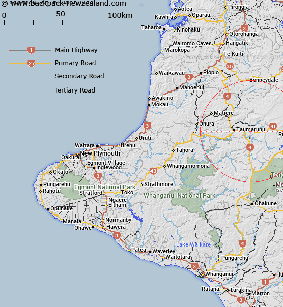
Map showing location of Pungapunga


LINZ description: Development scheme near Taumarunui on the southern bank of the Pungapunga River.
Latitude: -38.892762
Longitude: 175.393699
Northing: 5692400
Easting: 1807600
Land District: Taranaki
Feat Type: Site


Scroll down to see a more detailed road map and below that a topographical map showing the location of Pungapunga. The road map has been supplied by openstreetmap and the topographical map of Pungapunga has been supplied by Land Information New Zealand (LINZ).

Yes you can use the top static map for you school/university project or personal website with a link back. Contact me for any commercial use.

Pungapunga Map New Zealand


New Zealand places in our database
[ A ] [ B ] [ C ] [ D ] [ E ] [ F ] [ G ] [ H ] [ I ] [ J ] [ K ] [ L ] [ M ] [ N ] [ O ] [ P ] [ Q ] [ R ] [ S ] [ T ] [ U ] [ V ] [ W ] [ X ] [ Y ] [ Z ]


Closest 20 Sites to Pungapunga

Te Porere Redoubt (Upper) ( 23.61km )   Te Porere Redoubt (Lower) ( 24.32km )   Whareriki Pa ( 32.54km )   Pukewarangi ( 33.88km )   Puke Wharangi ( 33.88km )   McDonnells Redoubt ( 35.97km )   Hirangi Marae ( 36.37km )   Makakote Pa ( 36.53km )   Kaiwhakauka Pa ( 37.83km )   Hautu Pa ( 39.8km )   Korohoe Pa ( 41.3km )   Owairua Pa ( 41.96km )   Kirikiriroa Pa ( 42.62km )   Maungarongo Pa ( 57.95km )   Pakira Marae ( 59.32km )   Mokai Marae ( 59.88km )   Tieke Marae ( 60.28km )   Mangaraama Marae ( 61.93km )   Motiti Marae ( 66.78km )   Tirorangi Marae ( 67.58km )   Aratira (The Drop Scene) ( 68.53km )   Te Kawau Pa ( 70.14km )   Maniaroa Marae ( 71.38km )   Ngaroto Marae ( 72.61km )   Opepe Monument ( 73.05km )   Katikatiaka Pa ( 73.35km )   Paitahi Pa ( 73.52km )   Upokunui Pa ( 73.56km )   Ongarahu Pa ( 75.3km )   Waiu Pa ( 75.92km )   Whitely Memorial ( 76.06km )   Patokatoka Pa ( 76.81km )   Pohatuiri Pa ( 77.12km )   Piriaka Pa ( 77.51km )   Papatiki Redoubt ( 78.04km )   Otumatua Pa ( 78.13km )   Titoki Pa ( 78.29km )   Waiiti Redoubt ( 78.42km )   Te Keeti Pa ( 79.61km )   Aotearoa Marae ( 79.63km )