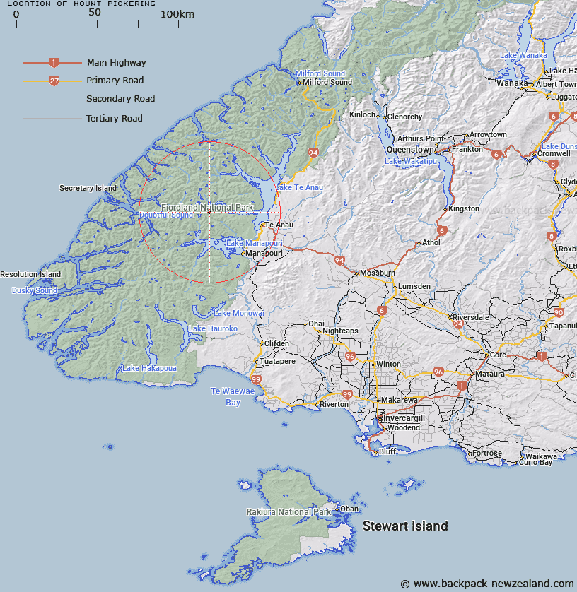
Map showing location of Mount Pickering


LINZ description: Prominent mountain, at height 1650m, located in the Kepler Mountains 20km west of Te Anau. NZTopo50 map CD07-Manapouri, GR 642 635.
Latitude: -45.346471
Longitude: 167.43761
Northing: 4963489.7
Easting: 1164256.9
Land District: Southland
Feat Type: Hill


Scroll down to see a more detailed road map and below that a topographical map showing the location of Mount Pickering. The road map has been supplied by openstreetmap and the topographical map of Mount Pickering has been supplied by Land Information New Zealand (LINZ).

Yes you can use the top static map for you school/university project or personal website with a link back. Contact me for any commercial use.

Mount Pickering Map New Zealand


New Zealand places in our database
[ A ] [ B ] [ C ] [ D ] [ E ] [ F ] [ G ] [ H ] [ I ] [ J ] [ K ] [ L ] [ M ] [ N ] [ O ] [ P ] [ Q ] [ R ] [ S ] [ T ] [ U ] [ V ] [ W ] [ X ] [ Y ] [ Z ]


Closest 20 Hills to Mount Pickering

Mount Martin ( 4.58km )   Mount Maury ( 4.67km )   Spire Peak ( 5.7km )   Mount Kidd ( 6.47km )   Mount Tinsley ( 7.06km )   Mount Fowler ( 8.69km )   Ardneil Peak ( 8.71km )   Mount Baird ( 9.45km )   Gerald Peak ( 9.99km )   Forward Peak ( 10.12km )   Mount Scott ( 10.14km )   Mount Lyall ( 11.09km )   Saint Pauls Dome ( 11.16km )   Mount Hall ( 11.22km )   Mount Fannin ( 11.41km )   Mount Owen ( 11.6km )   Mount Luxmore ( 12.74km )   Black Cone ( 14.91km )   Mount Max ( 15.54km )   Mount Soaker ( 15.57km )   Mount Wera ( 15.73km )   Mount Patanga ( 17.29km )   Beehive ( 17.49km )   Coronation Peak ( 18.09km )   Steep Peak ( 18.95km )   Mount Irene ( 19.72km )   Rectory Peak ( 19.82km )   Precipice Peak ( 20.4km )   Mount George ( 20.74km )   Harts Hill ( 21.24km )   Double Peak ( 21.39km )   Forden Peak ( 21.77km )   Leaning Peak ( 21.84km )   Miller Peak ( 22.61km )   Cone Peak ( 22.98km )   Mount Mainwaring ( 23.11km )   Mount Plaisted ( 24.04km )   Mount Barber ( 24.59km )   Turpentine ( 24.93km )   Pahiri Peak ( 25.46km )