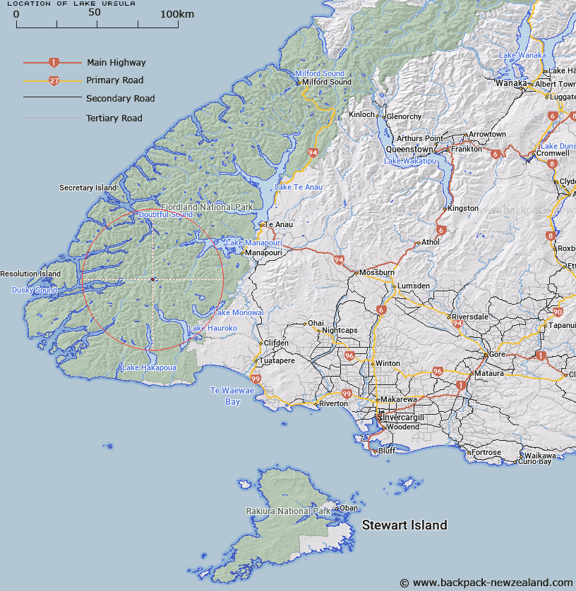
Map showing location of Lake Ursula


LINZ description: The small lake in the Heath Mountains on western tributary at head of Hauroko Burn, Fiordland National Park
Latitude: -45.699894
Longitude: 167.127646
Northing: 4922500
Easting: 1142857.6
Land District: Southland
Feat Type: Lake


Scroll down to see a more detailed road map and below that a topographical map showing the location of Lake Ursula. The road map has been supplied by openstreetmap and the topographical map of Lake Ursula has been supplied by Land Information New Zealand (LINZ).

Yes you can use the top static map for you school/university project or personal website with a link back. Contact me for any commercial use.

Lake Ursula Map New Zealand


New Zealand places in our database
[ A ] [ B ] [ C ] [ D ] [ E ] [ F ] [ G ] [ H ] [ I ] [ J ] [ K ] [ L ] [ M ] [ N ] [ O ] [ P ] [ Q ] [ R ] [ S ] [ T ] [ U ] [ V ] [ W ] [ X ] [ Y ] [ Z ]


Closest 20 Lakes to Lake Ursula

Lake Horizon ( 0.38km )   Lake Laffy ( 1.19km )   Lake Bright ( 1.45km )   Jane Lake ( 1.91km )   Lake Roe ( 2.12km )   Loch Maree ( 5.57km )   Lake Story ( 5.72km )   Gair Loch ( 8.58km )   Lake Saint Patrick ( 11.21km )   Lake Earnshaw ( 12.34km )   Lake Earnslaw ( 12.34km )   Lake Hay ( 13.32km )   Sphinx Lake ( 15.71km )   Shallow Lake ( 16.26km )   Moose Lake ( 16.86km )   Lake Jaquiery ( 17.36km )   Lake Louise ( 18.28km )   Lake Colwell ( 19.03km )   Lake Percy ( 20.23km )   Island Lake ( 20.37km )   Stump Lake ( 20.4km )   Shy Lake ( 21.68km )   False Lake ( 21.81km )   Lake Mike ( 22.89km )   Green Lake ( 23.42km )   Lake Mainwaring ( 23.47km )   Prong Lake ( 23.65km )   Lake Carina ( 23.87km )   Lake Virginia ( 24.46km )   Lake Troup ( 24.61km )   Lake Lucille ( 24.69km )   Lake Kakapo ( 25.7km )   Lake Lois ( 26.79km )   Trinity Lakes ( 27.1km )   Lake Matilda ( 27.21km )   Lake Lucy ( 27.28km )   Lake Widgeon ( 28.36km )   Monowai Lake ( 29.91km )   Lake Purser ( 30.04km )   Lake Norwest ( 30.21km )