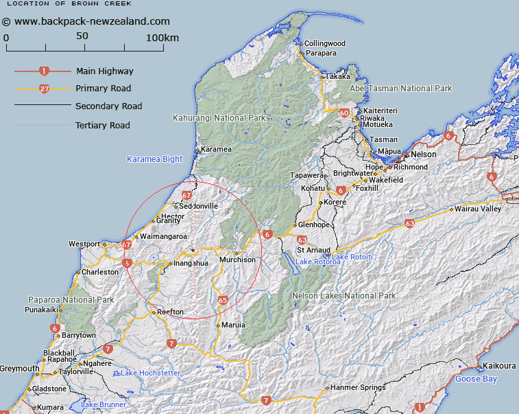
Map showing location of Brown Creek


LINZ description: Creek in the Lyell region of the Buller Gorge
Latitude: -41.781044
Longitude: 172.078964
Northing: 5374123.8
Easting: 1523460.7
Land District: Nelson
Feat Type: Stream


Scroll down to see a more detailed road map and below that a topographical map showing the location of Brown Creek. The road map has been supplied by openstreetmap and the topographical map of Brown Creek has been supplied by Land Information New Zealand (LINZ).

Yes you can use the top static map for you school/university project or personal website with a link back. Contact me for any commercial use.

Brown Creek Map New Zealand


New Zealand places in our database
[ A ] [ B ] [ C ] [ D ] [ E ] [ F ] [ G ] [ H ] [ I ] [ J ] [ K ] [ L ] [ M ] [ N ] [ O ] [ P ] [ Q ] [ R ] [ S ] [ T ] [ U ] [ V ] [ W ] [ X ] [ Y ] [ Z ]


Closest 20 Streams to Brown Creek

Murphys Creek ( 0.66km )   Brown Creek ( 0.66km )   Irishmans Creek ( 0.71km )   Englishman Creek ( 0.85km )   Scotties Creek ( 1.16km )   Lyell Creek ( 1.36km )   Eight Mile Creek ( 1.37km )   Deep Creek ( 1.97km )   Eight Mile Creek or Boundary Creek ( 2.72km )   Prythericks Creek ( 2.79km )   Foley Creek ( 3.09km )   Dublin Creek ( 3.12km )   Eden Creek ( 3.25km )   Blue Creek ( 3.67km )   Government Clear Creek ( 4.4km )   O'Roukes Creek ( 4.55km )   Little Deep Creek ( 4.55km )   New Creek ( 4.8km )   Tichborne Creek ( 5.34km )   O'Roukes Creek ( 5.9km )   O'Rourkes Creek ( 5.9km )   Brown Creek ( 5.9km )   Arnolds Creek ( 6.04km )   Carter Creek ( 6.11km )   Rodger Creek ( 6.21km )   Mountain Maid Creek ( 6.48km )   Big Deep Creek ( 6.83km )   Flaxbush Creek ( 7.8km )   Little Deepdale Creek ( 8.54km )   Pensini Creek ( 8.7km )   Slug Stream ( 9.06km )   De Filippi Creek ( 9.13km )   Deepdale River ( 9.42km )   School Creek ( 9.42km )   Brown Creek ( 9.42km )   Slate Creek ( 9.5km )   Pikopiko Stream ( 9.62km )   Spring Creek ( 9.95km )   Mossy Stream ( 10.11km )   Whale Creek ( 10.35km )