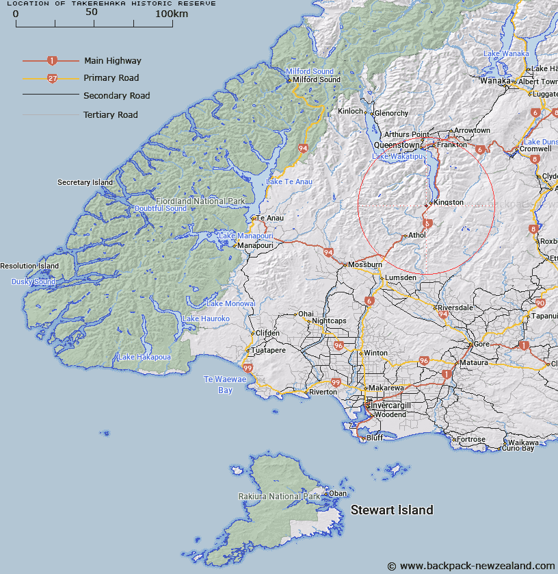
Map showing location of Tākerehaka Historic Reserve


LINZ description: Being Section 4 SO 441474 (16.444ha). Shown on NZTopo50-CD11 Kingston.
Latitude: -45.34767
Longitude: 168.691336
Northing: 4969390
Easting: 1262475
Land District: Southland
Feat Type: Historic Reserve


Scroll down to see a more detailed road map and below that a topographical map showing the location of Tākerehaka Historic Reserve. The road map has been supplied by openstreetmap and the topographical map of Tākerehaka Historic Reserve has been supplied by Land Information New Zealand (LINZ).

Yes you can use the top static map for you school/university project or personal website with a link back. Contact me for any commercial use.

Tākerehaka Historic Reserve Map New Zealand


New Zealand places in our database
[ A ] [ B ] [ C ] [ D ] [ E ] [ F ] [ G ] [ H ] [ I ] [ J ] [ K ] [ L ] [ M ] [ N ] [ O ] [ P ] [ Q ] [ R ] [ S ] [ T ] [ U ] [ V ] [ W ] [ X ] [ Y ] [ Z ]


Closest 20 Historic Reserves to Tākerehaka Historic Reserve

Muddy Gully Historic Reserve ( 32.67km )   Queenstown Astronomical Historic Reserve ( 35km )   Coal Pit Saddle Historic Reserve ( 37.74km )   Young Australian Historic Reserve ( 39.5km )   Kawarau Bridge Historic Reserve ( 40.96km )   Shek Harn Historic Reserve ( 41.89km )   Bannockburn Sluicings Historic Reserve ( 46.01km )   Arrowtown Gaol Historic Reserve ( 46.7km )   Arrowtown Chinese Settlement Historic Reserve ( 46.71km )   Bannockburn Post Office Historic Reserve ( 46.77km )   Mitchell's Cottage Historic Reserve ( 46.79km )   Atleys Terrace Historic Reserve ( 47.22km )   Earnscleugh Dredge Tailings Historic Reserve ( 53.18km )   Macetown Historic Reserve ( 54.36km )   Alexandra Courthouse Historic Reserve ( 55.77km )   Quartz Reef Point Historic Reserve ( 58.19km )   Bendigo Bake House Historic Reserve ( 69.32km )   Bendigo Historic Reserve ( 70.71km )   Invincible Mine Historic Reserve ( 71.42km )   Nine Mile Historic Reserve ( 95.51km )   Gabriels Gully Historic Reserve ( 96.93km )   Gabriel Read Memorial Historic Reserve ( 97.86km )   St Bathans Post Office Historic Reserve ( 102.56km )   St Bathans Hall Historic Reserve ( 102.6km )   Pioneer Stream Historic Reserve ( 106.56km )   Town of Nenthorn Historic Reserve ( 132.07km )   Golden Point Historic Reserve ( 135.56km )   Dead Horse Pinch Historic Reserve ( 136.76km )   Murphys Flat Historic Reserve ( 139.86km )   Sand Hill Point Historic Reserve ( 146.46km )   Horseshoe Bend Cemetery Historic Reserve ( 147.27km )   Sir John McKenzie Memorial Historic Reserve ( 159.99km )   Te-U-Mukuri Historic Reserve ( 165.27km )   Onewhenua Historic Reserve ( 166.53km )   Kotahitanga Church Historic Reserve ( 168.2km )   Katiki Point Historic Reserve ( 169.41km )   Jeanie Collier Grave Site Reserve ( 205.05km )   Monavale Historic Reserve ( 207.57km )   Raincliff Historic Reserve ( 224.48km )   Kakahu Lime Kiln Historic Reserve ( 231.5km )