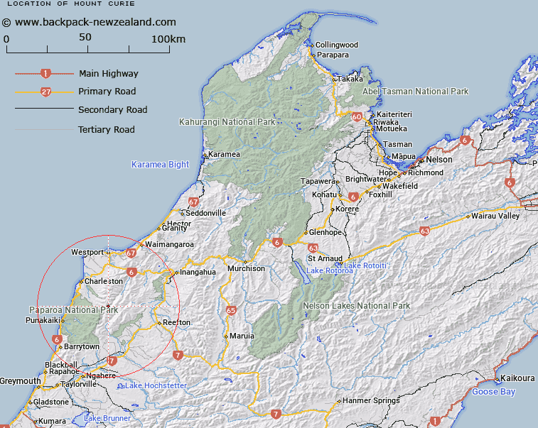
Map showing location of Mount Curie


LINZ description: Peak (1345m) in the Paparoa Range, 1.1km North North-east of Mount Faraday (Geodetic Code 1170). Block XVII Ohika Survey District.
Latitude: -42.028461
Longitude: 171.583097
Northing: 5346092.7
Easting: 1482706.5
Land District: Nelson
Feat Type: Hill


Scroll down to see a more detailed road map and below that a topographical map showing the location of Mount Curie. The road map has been supplied by openstreetmap and the topographical map of Mount Curie has been supplied by Land Information New Zealand (LINZ).

Yes you can use the top static map for you school/university project or personal website with a link back. Contact me for any commercial use.

Mount Curie Map New Zealand


New Zealand places in our database
[ A ] [ B ] [ C ] [ D ] [ E ] [ F ] [ G ] [ H ] [ I ] [ J ] [ K ] [ L ] [ M ] [ N ] [ O ] [ P ] [ Q ] [ R ] [ S ] [ T ] [ U ] [ V ] [ W ] [ X ] [ Y ] [ Z ]


Closest 20 Hills to Mount Curie

Mount Faraday ( 1.14km )   Mount Mendel ( 1.32km )   Mount Pasteur ( 1.99km )   Mount Einstein ( 2.59km )   Mount Micawber ( 3.98km )   The Pinnacle ( 4.8km )   Mount Uriah ( 5.09km )   Mount Rutherford ( 5.78km )   Mount Priestley ( 5.83km )   Mount Priestly ( 5.83km )   Mount Dewar ( 6.76km )   Mount Euclid ( 7.61km )   Mount Ramsay ( 7.75km )   Gunsight Notch ( 7.91km )   Mount Fleming ( 8.46km )   Mount Epping ( 8.48km )   Mount Lodge ( 8.74km )   Mount Beeche ( 8.92km )   Mount Stevenson ( 9.02km )   Mount Lavoisier ( 9.6km )   Mount Raoulia ( 10.74km )   Mount Wise ( 10.8km )   Mount Kelvin ( 11.29km )   Mount Steele ( 11.92km )   Mount McHardy ( 12.37km )   Mount Bovis ( 12.4km )   Mount Copernicus ( 14.2km )   Needle ( 14.31km )   Mount Johnston ( 14.71km )   Mount Galileo ( 14.8km )   Mount Marshall ( 15.28km )   Buckland Peaks ( 16.24km )   Lone Hand ( 16.98km )   Mount Pecksniff ( 17.2km )   Costello Hill ( 18.29km )   White Knight ( 18.78km )   Parsons Hill ( 18.89km )   Giants Grave ( 19.27km )   Waikori ( 20.19km )   Hawera ( 21.14km )