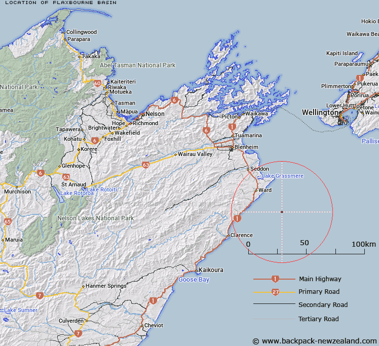
Map showing location of Flaxbourne Basin


LINZ description: Marlbourough Shelf, South Island. An enclosed basin on the outer continental shelf off the east coast of Marlborough. About 40 m deeper than the surrounding 130 m deep continental shelf.
Latitude: -41.983333
Longitude: 174.333333
Northing: 5351214.5
Easting: 1710453.4
Land District: Marlborough
Feat Type: Basin


Scroll down to see a more detailed road map and below that a topographical map showing the location of Flaxbourne Basin. The road map has been supplied by openstreetmap and the topographical map of Flaxbourne Basin has been supplied by Land Information New Zealand (LINZ).

Yes you can use the top static map for you school/university project or personal website with a link back. Contact me for any commercial use.

Flaxbourne Basin Map New Zealand


New Zealand places in our database
[ A ] [ B ] [ C ] [ D ] [ E ] [ F ] [ G ] [ H ] [ I ] [ J ] [ K ] [ L ] [ M ] [ N ] [ O ] [ P ] [ Q ] [ R ] [ S ] [ T ] [ U ] [ V ] [ W ] [ X ] [ Y ] [ Z ]


Closest 20 Basins to Flaxbourne Basin

Teme Basin ( 62.47km )   Gore Basin ( 91.65km )   Stonewall Basin ( 93.38km )   Narrows Basin ( 95.3km )   1st Basin ( 127.04km )   2nd Basin ( 128.08km )   3rd Basin ( 128.96km )   4th Basin ( 129.85km )   Sanctuary Basin ( 156.59km )   Poverty Basin ( 156.98km )   Castle Basin ( 157.01km )   Nardoo Basin ( 157.27km )   Horseshoe Basin ( 160.98km )   Bannister Basin ( 167.21km )   Taylor Basin ( 167.9km )   Shelter Rock Basin ( 181.94km )   Zetland Basin ( 182.69km )   Twenty Four Tarn Basin ( 182.75km )   Rochfort Basin ( 218.48km )   McNulty Basin ( 263.31km )   Back Basin ( 269.45km )   Moa Basins ( 280.67km )   Cattle Basin ( 285.41km )   Mistake Basin ( 287.8km )   Boundary Basin ( 288.36km )   Cookies Basins ( 289.32km )   South East Basin ( 314.05km )   Sandys Basin ( 335.88km )   Camp Basin ( 339.81km )   Cooks Horn Basin ( 341.52km )   Scour Basin ( 341.74km )   Balaclava Basins ( 342.44km )   Iliad Basin ( 344.88km )   Odyssey Basin ( 345.65km )   Mackay Basin ( 348.99km )   Tindill Basin ( 353.7km )   Stony Basin ( 356.14km )   Lagoon Basin ( 403.9km )   Waterfall Basin ( 428.95km )   Kea Nest ( 430.45km )