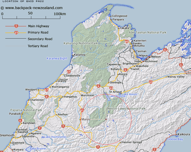
Map showing location of Enid Pass


LINZ description: Pass between Mount Humbolt and Enid Peak, connecting an upper tributary of Enid Stream to the head of an unnamed stream flowing into the Matakitaki River East Branch, in the Spenser Mountains.
Latitude: -42.182916
Longitude: 172.614078
Northing: 5329842.4
Easting: 1568130.5
Land District: Nelson, Canterbury
Feat Type: Pass


Scroll down to see a more detailed road map and below that a topographical map showing the location of Enid Pass. The road map has been supplied by openstreetmap and the topographical map of Enid Pass has been supplied by Land Information New Zealand (LINZ).

Yes you can use the top static map for you school/university project or personal website with a link back. Contact me for any commercial use.

Enid Pass Map New Zealand


New Zealand places in our database
[ A ] [ B ] [ C ] [ D ] [ E ] [ F ] [ G ] [ H ] [ I ] [ J ] [ K ] [ L ] [ M ] [ N ] [ O ] [ P ] [ Q ] [ R ] [ S ] [ T ] [ U ] [ V ] [ W ] [ X ] [ Y ] [ Z ]


Closest 20 Passs to Enid Pass

D'Urville Pass ( 5.33km )   David Saddle ( 5.81km )   Thompson Pass ( 6.56km )   Maling Pass ( 7.04km )   Waiau Pass ( 9.74km )   Paske Saddle ( 11.35km )   Clarence Pass ( 12.28km )   Moss Pass ( 13.89km )   Island Saddle ( 14.86km )   Island Pass ( 15.23km )   Glenrae Saddle ( 15.56km )   Three Tarn Pass ( 16.28km )   Fowlers Pass ( 16.72km )   Ada Pass ( 18.43km )   Saddle Spur ( 19.36km )   Rainbow Pass ( 19.39km )   Travers Saddle ( 19.96km )   Poukirikiri / Travers Saddle ( 19.96km )   Begley Saddle ( 21.2km )   Henry Saddle ( 24.21km )   Mole Saddle ( 25.43km )   Anne Saddle ( 26.03km )   Rappahannock Saddle ( 26.58km )   Edwards Pass ( 26.81km )   Peters Pass ( 27.78km )   Lewis Pass ( 27.93km )   Alma Saddle ( 28.1km )   Charlies Saddle ( 28.29km )   Tiraumea Saddle ( 29.18km )   Five Mile Saddle ( 30.39km )   Maruia Saddle ( 31.2km )   Sunset Saddle ( 32.48km )   Yarra Saddle ( 33.08km )   Bristol Pass ( 34.92km )   Shenandoah Saddle ( 35.17km )   Jacks Pass ( 37.19km )   Isolated Saddle ( 38.68km )   Jollies Pass ( 40.9km )   Waitahu Saddle ( 41.57km )   Severn Saddle ( 42.38km )