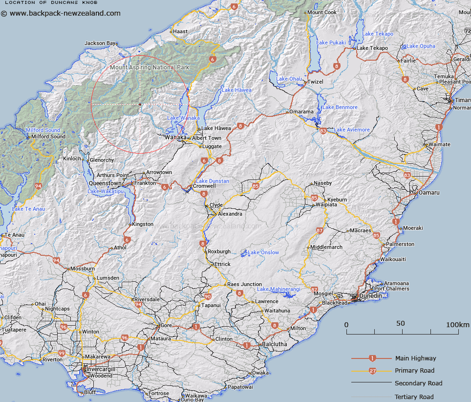
Map showing location of Duncans Knob


LINZ description: Peak at the end of the eastern ridge of, and 4.6km East of Mount Avalanche. Matukituki Survey District.
Latitude: -44.426304
Longitude: 168.799195
Northing: 5072188.4
Easting: 1265618.8
Land District: Otago
Feat Type: Hill


Scroll down to see a more detailed road map and below that a topographical map showing the location of Duncans Knob. The road map has been supplied by openstreetmap and the topographical map of Duncans Knob has been supplied by Land Information New Zealand (LINZ).

Yes you can use the top static map for you school/university project or personal website with a link back. Contact me for any commercial use.

Duncans Knob Map New Zealand


New Zealand places in our database
[ A ] [ B ] [ C ] [ D ] [ E ] [ F ] [ G ] [ H ] [ I ] [ J ] [ K ] [ L ] [ M ] [ N ] [ O ] [ P ] [ Q ] [ R ] [ S ] [ T ] [ U ] [ V ] [ W ] [ X ] [ Y ] [ Z ]


Closest 20 Hills to Duncans Knob

Mildewed Meg ( 2.11km )   East Peak ( 4.16km )   Middle Peak ( 4.31km )   Moncrieff Peak ( 4.61km )   Mount Avalanche ( 4.64km )   Aeroplane Peak ( 4.65km )   Mount Eostre ( 4.94km )   Homestead Peak ( 5km )   Scylla and Charybdis ( 5.56km )   Low Peak ( 5.57km )   Popes Nose ( 5.74km )   Sisyphus Peak ( 6.2km )   Dragonfly Peak ( 6.65km )   Rob Roy Peak ( 6.79km )   Mount French ( 6.81km )   Fastness Peak ( 7.13km )   Mount Aspiring/Tititea ( 7.25km )   Mount Aspiring ( 7.25km )   Mount Joffre ( 8.57km )   Glengyle Peak ( 8.78km )   Glenfinnan Peak ( 9.68km )   Mount Bevan ( 9.79km )   Rolling Pin ( 9.98km )   Glacier Dome ( 10.01km )   Mainroyal ( 10.32km )   Fog Peak ( 10.74km )   Skyscraper ( 11.03km )   Niger Peak ( 11.38km )   Stargazer ( 11.39km )   Sharks Tooth Peak ( 11.64km )   Mount Barff ( 11.64km )   Pickelhaube Peak ( 11.97km )   Pickelhaube ( 12.03km )   Triple Peak ( 12.31km )   Craigroyston Peak ( 12.83km )   Spike ( 12.87km )   Bow Peak ( 13.15km )   Islington Dome ( 13.45km )   Mount Liverpool ( 13.77km )   Aspinall Peak ( 13.85km )