Travers Sabine Circuit
Quick Facts
- Distance: 79 km
- Time: 6 - 8 days
- Grade: Medium / Fit
- Higest point: 1770 m
- Island: South
- Location: Nelson Lakes National Park
- Map: St Arnaud N29, Murchison M29, Tarndale N30, Matakitaki M30
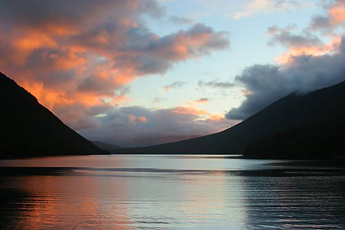
Starting from Kerr Bay camping ground, the Lake Head Track sidles the eastern side of Lake Rotoiti. The start of the track is quite literally a walk in the park. For the first leg of this route, be prepared for the customary "hi"'s and "bye"'s to a plentitude of joggers, day walkers, kids, etc. The first section is so easy that on our arrival at Lake Head Hut we found a couple of families had brought along their kids with the youngest being no older than seven.
The first km is a wide and easy path until it meets the Loop Track junction. The next 4 km follows a well-beaten path through red, silver and black beech forest winding along Lake Rotoiti. Having passed two clearings which offer good views of first the north and then the southern side of the lake, Lake Head Hut (36 bunks) is situated on a pleasant grassy bank overlooking the mouth of Travers River. You might want to nab your place immediately as this hut was soon to be filled to the brim. This spot is popular not only for day walkers but also for trout fishing. Alternatively, you may want to lay yourself to rest at the older and more romantic Coldwater Hut (6 bunks) which is only 800m away. Those with less time or energy can take a water taxi from St Arnaud to the jetty which is about 200m away from Lake Head Hut.
Lake Head Hut to John Tait Hut
Signs will direct you along the left side of the river over wide grass flats for 3km/1hr. The track now returns to bush before meeting the river and footbridge after a further km/20 minutes. Heading south up the west bank, the forest hugs the river for another 3.5km. Mt Travers, standing at 2338m, looms ahead dominating the horizon and inspiring your progress. You will pass through beech and grassy flats until you meet the footbridge crossing Hopeless Creek. On the far side, signs will direct you either toward Hopeless Hut (2 1/2hrs) or John Tait (2 hrs/5kms). The track now follows a gradual slope through enclosed forest until you emerge into a small, grassy clearing. John Tait Hut (36 bunks), is a pretty spot sitting close to river and providing a good view of the mountain peaks.
John Tait Hut to Upper Travers Hut
The walk in the park is now gone for good. The incline now begins to steepen as you make your way along the track. After 1km/20 mins the track meets a junction to Cupola Basin and then crosses a footbridge. Another 1km/20 mins later, you will pass a sign directing you toward the Travers Waterfall. It's only 3 minutes away and would be a crime to skip. The waterfall thunders down impressively into a clear pool of mossy rock.
At this stage, the track is now rooty and climbs over the Summit Creek footbridge. After another 2km/40mins you will cross to the east side of the Travers River over another footbridge. You will now continue climbing through thick mountain beech to the bush line where your efforts will be rewarded with the sight of the Travers and St Arnaud ranges. Upper Travers Hut is a picturesque hut on the alpine margin surrounded by gravel and scree slopes which offer easy climbing for better views.
Upper Travers Hut to West Sabine Hut
It's an off-beaten track up the Travers Saddle which is nonetheless well-marked with rock cairns and snow poles. Keep an eye out for the mountain flowers and numerous, multi-coloured grasshoppers. You will zig-zag up tussock slopes and large boulders for 2km/2-3hrs until you reach the pass. It's slow going but each pause for breath is rewarded with spectacular views. The sight from the Saddle itself will take your breath away with 360 degree views of peaks and valleys. Have your sun-protection handy though as there's definitely no ozone left here.
For the descent you will need sturdy knees, a sense of humour and a ready supply of swearwords. Its begins tranquilly enough over tussock slopes and boulders until you reach the end of the bush. Fun for some and hell for mere mortals like myself, the track now descends into a steep scree covered gully. It's easier to make your own route as there's less slide than on the track itself. Keep a sharp eye out for the cairn marking the track at the treeline.
The worst is over and the East Sabine Gorge will return your spirits back to good humour. You will cross a footbridge to the sound of water belting approximately 30m into the river. It's only 3m wide and so deep and dark that you will not be able to see the water. Back in the bush you will now need to navigate your tired feet over a multitude of slippery roots. After one last steep descent, the track now heads south. Having crossed a footbridge, the recently built West Sabine Hut (35 bunks) is a welcome sight for tired feet.
If you've got enough time and supplies, do head up to the Blue Lake. I wouldn't have missed it for the world. The name is no misnomer. The lake shimmers with different hues of pale to dark blue. Surrounded by bush and peaks, the colours of the lake change in accordance with the time of the day. If you've got the guts, the freezing cold water makes a great, quick dip. Alternatively, take a load off, lie down and have a siesta. I did both and felt like a million dollars. My traveling partner continued to Lake Constance which he reported to be beautiful in a bleak, kinda way. From there you also get to see Mt Franklin (2339m) the highest point in the Nelson Lakes.
West Sabine Hut to Sabine Hut
The day's walking will seem easy after all the climbing and descending. The track starts from the swing bridge over the West Sabine River. It's a walk along the west bank of the lake for the next 7km until the track emerges onto a grassy flat which continues for another 2kms. You will then cross a swing bridge over a lovely little gorge. This is also a lovely, swimming spot shared with the trout who are often to be found chilling in the shade of the rocks. From here, it's a mere 2km/40mins to the spacious Sabine Hut (36 bunks). This newly-built hut overlooks Lake Rotoroa. There's also a jetty here and a taxi-service is provided via a telephone in the hut. This is another great place to swim provided you've no objection to eels which are plentiful. Beautiful as it is, the sand flies are absolute murder, I'm almost convinced they've developed a resistance to insect repellent in this area. Oh and watch out for the wasps. They're pretty, nasty little buggers if you happen to step on one like i did.
Sabine Hut to Speargress Hut
This track was built as an alternative to the more arduous track to Mt Angelus which may fall foul to bad weather conditions. From Sabine Hut the track heads north along the lake and past the junction to Mt Angelus. This was once the Howard Hut route and passes through beech forest. 2kms/2hrs along the way, you will come to a good-looking wet-land saddle. A good spot for a wee break, it offers a bench and a pleasant, tussocky view. There are three streams to be crossed; the Cedric, Tier and Hodgson. There's a fair bit of ups and downs although the greater part of the track is boardwalked. The track branches off to the right, heading southeast to the Speargrass Hut (6 bunks) which is to be found in a grassy clearing. I loved this old, rustic and ramshackle little hut.
Speargress Hut to Mount Robert Car Park(2.5 hrs)
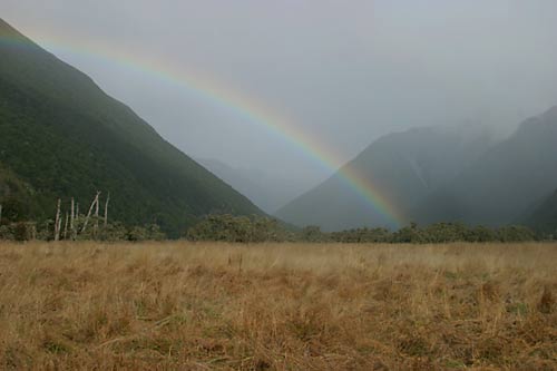
The track slopes gently down to Speargrass Creek. Having crossed a footbridge, you will continue along the bush valley before descending gently to a creek. The track then climbs leisurely for about 1.5km/30mins to Robert Ridge car park. Unless you've got transport, it will take a further 5km/1hr to reach St Arnaud.