South Coast Track
Quick Facts
- Distance: 34 km return to Port Craig - 66km return to Wairaurahiri Hut
- Time: 2 - 4 days
- Grade: Easy
- Higest point: 65 m
- Island: South
- Location: Fiordland National Park/li>
- Map: Port Craig C46
The southern coast of the South Island can be bitterly cold and at times the rain relentless. With this in mind you can truly appreciate the feats of the pioneers whom built this now defunct railway and the massive viaducts.
Sea birds are in abundance with oystercatchers, terns, gulls and shags all enjoying the plentiful supply of fish in this area of the world. If you are lucky you may also see a Hector's Dolphin, the smallest and rarest dolphin in the world which is only found in New Zealand.

The track starts off by following a newly built track with signs pointing out the names of local flora. After 2 km the track descends fairly steeply and comes to a footbridge, cross this and you will come to the Waikoau holiday homes.
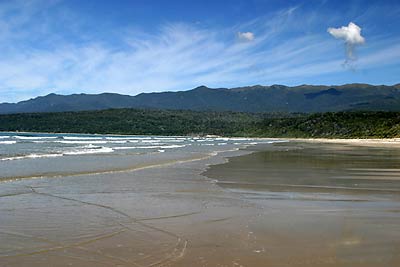
Either make your way to the beach and follow the lovely golden sands for about 2.5 km /1 hour or keep to the road.
There are two ways to get to Port Craig. You can either keep following the coast (as we did) or stick to the track. If the seas aren't to rough the coastal way is well worth it, it's a bit slower and harder on the ankles though.
If you want to get yourself a feed of mussels pick them off the rocks at the end of the beach and carry them with you. The rocks at Port Craig were almost totally stripped of mussels when we did this track.
If you decide to keep to the track make your way up the bank just before the end of the beech and follow the former logging road until it comes to a dead end. Otherwise just keep following the coast.
At the end of the logging road is the start of the Waitutu track. Follow the well graded track for 2 km and you will come to a footbridge. Cross this and you will find a track junction, the track on your right heads up to Okaka Hut (Hump Ridge Track).
After 200 metres or so the track comes to a small sandy beach. Make your way to the end of the beach and head up and over the headland to another beach. This beach is more rocky and if the seas are right you will see why this beach is aptly named The Blowholes.
Follow this beach for 1 km and at the end you can either head inland or follow the coast. The inland track is used if it is high tide. Although we never went this way it is apparently a gut buster.
The low tide route is fairly easy, occasionally you will have to do some bolder hopping, but nothing too demanding. After following the coast for about 3.5 km you will come to a track that heads steeply up to rejoin the high tide route. Follow the track for a further 1.5km and you will come to Port Craig Hut (22 bunks).

It's a 5 minute walk down to the beach where rusty bits of machinery, bolts and other relics are scattered around.
You will also pass the eyesore of a hut that is part of the Hump Ridge Track. I say eyesore because it is more of a hotel/lodge than a trampers hut. It has hot showers and other mod-cons.
While we were down at the beach we were fortunate to be accompanied by a pod of Hector Dolphins. They must have only been about 10 metres from the shore.
Port Craig - Wairaurahiri River Hut: 16 km / 5 hrs This section mostly follows a old tramway almost the entire distance to Wairaurahiri Hut. It's very easy and at times monotonous as large sections are completely flat and straight.

After 4 km's the tramway gives way to a somewhat muddy track and it is a further 500 metres to Wairaurahiri River and the hut. This 12 bunk hut has hot water which is heated up by the old steel fire place.
As we were running out of time we decided to head back to Blue Cliffs car park. You can however continue and a hunter we talked to told us that the next section is worth it as you go through a mature rimu forest.

Waitutu River - Big River: 12 kms / 5 - 7 hrs