Queen Charlotte Track
Quick Facts
- Distance: 71 km
- Time: 3 - 5 days
- Grade: Easy
- Higest point: 450 m
- Island: South
- Location: Marlborough
- Map: Marlborough Sounds, 260 P27/ 260 Q26
Getting There
Trail is just west of Picton, at the northern end of the South Island. Catch the Interislander Ferry from Wellington which lands directly in Picton (very convenient, this is what I did) or drive from anywhere on the South Island. Nearly everybody will start their trip from Ship's Cove, which is only accessible via boat. There are a number of boat operators which all leave from the Picton town wharf, which is only a three minute walk from the ferry station, and adjacent to the town center
Ship's Cove - Resolution Bay: 4.5 km, 2 hrs
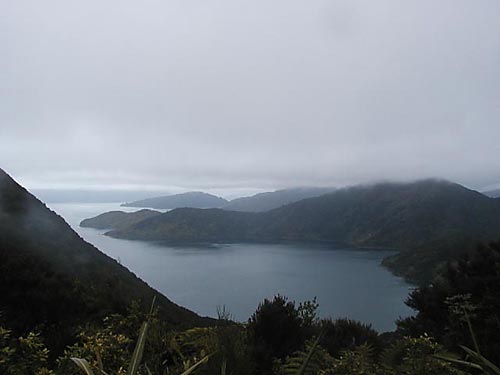
From the the boat landing climb for about 35-45 minutes to a nice lookout, looking out to the Cook Strait, and to where you are heading. Descend past the first DOC campsite, to Resolution Bay, a small place that has muffins and some cabins.
Resolution Bay - Endeavor Inlet: 10.5km, 3 hrs
Climb to a short saddle, then descend slowly past some private houses into Endeavor inlet. You will find Forneaux lodge, the largest resort on the trail, with a restaurant, cabins and a backpackers. There are number of other lodging options here as well.
Menander just above the shore around a few coves all the way, probably the flattest part of the trail. If continuing on past Camp Bay towards the Bay of Many Coves there is a cutoff that saves about 1.5 hrs, by not descending to the water's edge at Camp Bay.
Camp Bay to Torea Saddle: 8 hr, 24.5 km (3 hrs to campsite at Bay of Many Coves)
Steady climb for about an hour until you reach a rolling ridge line that you travel along all the way to Torea Saddle. This is probably the most difficult section of trail. About 9km from Camp Bay, you will reach the DOC Bay of Many Coves campsite, and shortly there after the trail down to the Bay of Many Coves resort area. About another 9km, and you reach the DOC Black Rock Campground. Both of these have great views as they are high above the water on the ridge. Walk down the road at the saddle to get to the campground here or Portage resort.
Torea Saddle -Mistletoe Bay: 7.5 km, 4 hrs
This section is just up and down two medium height hills. Probably my favorite section of the track. Great views to both sides of the ridge you walk on.

Flat and then slowly dropping to the water's edge as you approach Anikiwa. About 2km from the end of the track you come across the last DOC campground, which looked like it probably sees a lot of traffic due to its location as a short walk from Anikiwa, but it is also a nice little beach and would probably be great to stay at. Don't expect much in the way of services in Anikiwa, it has a limited-selection cafe and a backpackers. There's no real services here. I thought it would be a town, but its really just some houses, so don't expect anything fancy.
Summary
This was a fun weekend trip, and a challenge, as I pushed myself to get it done in 2 days. Could be a vary relaxing trip, and easy enough for the whole family, especially if you are having your packs transported. The track was pretty muddy in places, so have good shoes or boots if you want to stay dry and on your feet.