Cape Reinga Coastal Walkway
Quick Facts
- Distance: 35 km
- Time: 4 days
- Grade: Easy / Moderate
- Higest point: 285 m
- Island: North
- Location: Northland
- Map: North Cape - 260-M02 & N02
I went in the end of August, and the weather was phenomenal. I only had my summer bag, which is rated to about five degrees, and I was a little chilly on some of the nights, but other wise quite good. It was also quite empty - I only saw 2 other hikers, and a couple others, who will be described later.
This area is of great spiritual importance to the Maori's, as this is where they say their soul's go to descend into the ocean to travel back to their homeland, and its also a really beautiful place.
Getting There
The night before I hit the trail, I stayed at the Waitiki Landing Complex, which is the last service station/backpackers/facilities on the North Cape. It is about 20km via dirt road from here to the Cape Reinga lighthouse, and 100km north of Kaitaia on HWY 1. They are a BBH hostel, have $7 campsites, and will organize a pick up and dropoff through another local company to get on and off the trail ($40). There is a restuarant/bar and liquor shop. If you need any last minute supplies, you can pick up basic food stuffs and stove fuel here, but it would be best to do your shopping in Kaitaia, as the Waitiki folks may well be out of what you need. There was also a backpackers just south of Pukenui that gave rides to the trail, but it costs $60 from there.
Once your there
There are no huts along this track, so you are going to want to pack your tent. Most people do this track from west to east, starting just off of Ninety Mile Beach, and hiking there way around to the Spirits Bay campground. This was the way I hiked.
Day One: ~10 km, 4 hrs
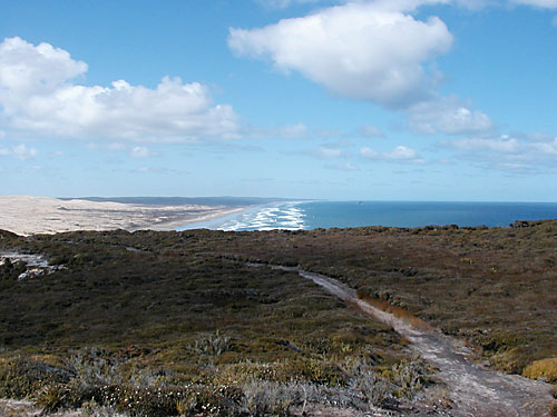
You are dropped off about 2km from Ninety Mile Beach at the back side of the sand dunes, from here you will hike out to the water along the stream, and then turn and follow Ninety Mile Beach to its end, about 2km more. The next portion you climb into a coastal hill, following the stairs up, and their are small posts marking the trail, which is well maintained for the most part. Follow on the hill for about 2km, then back down to a nice little beach (Twilight Beach). Continue along the beach, till its end.
Here was the first time I think I got lost. On the map, there is a trail that heads inland right towards the end of the beach, I saw trail markers maybe 200m from the end of the beach, at about the right spot, and assumed that was the trail heading inland. I continued on and couldn't really see a trail at the end of the beach, but there was a very small water runout, that looked like it had been walked before. Needless to say, this took me into a martian-type landscape, but I continued until I finally saw the trail markers, and traversed back to them. I don't think I went the correct way, but I made it, just continue up hill until you see the markers, or try the marked trail!
From here you will tramp over some rolling hills down towards the old lighthouse, which is about an 1 1/2 return from the trail, branching off before you round Herangi Hill (looks like a sand volcano). I didn't take it, but it looked like a really cool place to go explore down near the water. Continuing on, you will pass behind Herangi Hill, and then drop down to a small stream, which is a good water source, and where I camped the first night. My guess is that quite a few people camp here, as it is only an hour hike from the Cape Reinga parking area, but for me, I had the whole beach to myself.
Day Two: ~15km, 6 hrs
Day two is the most difficult day, going from the hills and back 3 times, but it also has the best views. Departing in the morning, you will cross a few km of beach, and then hike up the hill to the lighthouse. There is water and restrooms at the lighthouse, and if you want to send out a mid-tramp letter, their are post boxes!
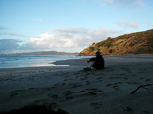
From the lighthouse area, you will descend steeply to Sandy Bay. This place is gorgeous! I would highly recommend camping here. I was very jealous of the solitary camper who was packing up his tent as I tramped by. It is a very small beach, about 30m wide, in a little inlet, with hills rising above it on both sides, beautiful little hideaway. If you are after a super short night out, park at the carpark, and cruise down to this hideout.
Day Three: ~9km, 2.5hrs
I was walking pretty fast for this section (see Appendix A), but essentially you just cruise around Spirits bay, which is a whole lot of beach, if it had been warmer, I probably would have stopped, and jumped in, and just taken my time. The campground and pick up are at the end of the beach, and this is where I just hung out for the rest of the day, and was picked up the next morning.
Overall
I thought this hike was great. It was my first NZ tramping experience, and being from Colorado, we have pretty good mountains, but no beaches, so being near the water was great. It will be consistently warmer here than the rest of NZ, so it makes a good winter getaway. I would definitely recommend this tramp.
Recommendations
I didn't like being at the campground the last night. I was the only one there, but it kind of defeated the purpose of my being there. I would have rather spaced it out more, and camped at Pandora the last night, and gotten up earlier and hiked before I was picked up. I would also suggest in in reverse: start at noon and camp at Pandora, then Sandy Bay, and finally the end of 90 Mile beach.
If you wanted to make your trip longer, you could add on about 2-3 days, by hiking out to the NE end of the peninsula. This is on Maori land, and you will have to get permission to go there. If you call the Waitiki Landing people, they would probably know how to do so. I met an Englishman who was going to hike out there. He was just talking to the locals at the bar the night before and seemed to think that would work, but I wouldn't rely on it.
Appendix A
I am at Pandora in the morning of the third day, packing up my tent, and brushing my teeth. I look up and see some people coming around the bend, with a few dogs, and continue to pack up. I look up a little later, and see that there are three guys with like 9 dogs coming straight for me! I give them a friendly wave, but get no wave back. Uh okay. They reach the stream, start to cross it and commence yelling at me "Hey you can't f@#king camp here!" As they get closer, I notice that they all have 12 inch long knives, and one of them has a gun slung around his back (okay, now I am pretty scared). "What are you doing camping here?! You can't camp here! We don't want your S#!t everywhere" At this point I have stopped brushing my teeth, but still have my toothbrush in my mouth (hold on let me spit toothpaste all over, just to piss you off more). So I do my best to suffice them, and tell them I didn't know I couldn't camp there (which you certainly can), and say I am leaving. So I pack up and cruise down the beach right quick.
Apparently there are 400 pound pigs in the area, who knew? The guy who gave me a ride said that they were probably hunting without a permit, and just trying to scare me so that I wouldn't mention it. Well they spoked me pretty well!
By Reid.