Abel Tasman Inland Track
Quick Facts
- Distance: 37.5 km
- Time: 3 - 5 days
- Grade: Medium / Fit
- Higest point: 1020 m
- Island: South
- Location: Abel Tasman National Park
- Map: Tarakohe N25; Takaka N26
Day 1
Marahau - Castle Rock Hut: 4.5 hr / 11.5 km (8 Bunks)
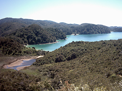
The start of the tramp begins at the main entrance to the Abel Tasman National Park. For the first couple of hours you will be following a path typical to the Great Walks. That is, full of people and either boardwalked or made of gravel. The start itself is impressive. Having entered the park, you cross the Marahau Estuary. Here the blues, greens and yellows that dominate the Abel Tasman landscape will immediately become apparent. A gentle climb will lead you to a clearing at Tinline Bay. Continue on to Tinline Bay Campsite and soon afterwards you will see the sign marking the beginning of the Inland Track. This is the most difficult leg of this tramp. You will start a gradual climb which sidles the hill, varying between bush and exposed track. (Have your sun-protection handy.) The views are out of this world. You will be able to see. Unfortunately, the Holyoake Hut is no longer being maintained by DCC so its advisable to carry a tent with you unless you don't mind roughing it. It's a lovely place to wake up though and the sunrise here was beautiful. There were also a couple of weka hanging out here. If you prefer the comfort of a hut, continue through the bush to Castle Rock Hut (10 bunks). The hut is pleasantly located in a clearing. There's a vague sign pointing in the direction of the Castle Rocks lookout. It takes about 20mins to get there and the view is definitely worth the effort. It overlooks the Marahau estuary and is also home to the lovely manuka and some very busy bees. Make sure you're on the right track here. I got lost and ended up scrambling my way down through some very prickly stuff. (Again, search me for the name of it!). It did rip my skin to shreds though and I ended up losing my specs in the process. So there I was, half blind and suffering from dehydration in the mid-summer, mid-day heat, until I found a creek and followed it back to the track. I wasn't the only one who lost the way either so just be sure to keep your wits about you.
Day 2
Castle Rock Hut - Moa Park: 2 hr /3.5 km (4 Bunks)
This leg of the track stays in the bush and the sea is no longer visible. You are now embarking on a 350m ascent over a distance of 3.5km. It's a pleasant walk though and the bush is alive with birds, although I can only be sure to have seen robins and fantails, as for the others, I've no idea what they were. Carrying along your merry way, you will pass the turn off to Porter's Rock, a lookout which quite frankly wasn't much to write home about. It's only 1km or 20 minutes away from the hut though and is also surrounded by a variety of different species of trees. Moa Park Hut is a delight. It's old, quaint and rustic and placed a few metres away from a stream. It's deep enough to have a dip or a wash. I also spotted a few wee freshwater crayfish here chilling in the shade of the rocks.
Day 3
Moa Park - Wainui Hut: 1 1/2 hr / 4.5 km (4 Bunks)
Cross the stream in front of the hut and you will start gently climbing through dracophyllum forest to Evans Ridge. It's easy going here weaving through the bush and emerging onto farmland. To a foreign eye, it is beautiful and if I were a cow I might just have decided to stay put. The track then enters the bush again briefly before descending into a clearing. The Wainui Hut is another delightful old hut which was built by gold miners in the 1930s.
Day 4
Wainui Hut - Awapoto Hut: 5 hr / 6.5 km (12 Bunks)
Bush, bush, bush, birds, bush is the order of the day. Fortunately, you're descending steadily all the way. This is virgin forest and some of those trees were simply massive - the roots look like something out of Jurassic Park. Awapoto Hut is one of the modern DOC huts and will seem quite luxurious after the rustic predecessors.
Day 5
Awapoto Hut - Wainui Car Park: 5 hr / 7.5 km
The track from the huts starts with a descent, then steepens for a short while before descending steeply toward Pigeon Saddle. The track then climbs a little and crosses a turnoff to a good look-out. Its a short climb to Gibbs Hill. From here the track descends first steeply and then more gradually, weaving along the ridge top, through bush, scrub and open farm land. This section sports the best views to be found in the entire park given a clear day.