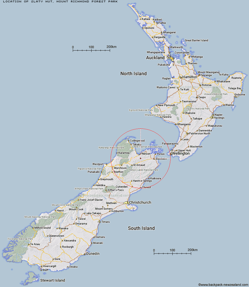
Topo Map showing location of Slaty Hut
This information is sourced from DoC, LINZ and Openstreetmap. Some of the hut photos are mine and the rest are from DoC. I will be adding an upload feature soon so people can photos of .Slaty Hut.
Basic info: standard 6-bunk hut in the Motueka area.
Latitude: -41.4854904221
Longitude: 173.278412857
Location: Mount Richmond Forest Park
Area: Nelson/Tasman
Type of Hut: Standard
Tracks: Alpine Route
Map: BQ26 Topo Map | Road Map
Does this hut still exist? Have any more information? Contact
Basic info: standard 6-bunk hut in the Motueka area.
Latitude: -41.4854904221
Longitude: 173.278412857
Location: Mount Richmond Forest Park
Area: Nelson/Tasman
Type of Hut: Standard
Tracks: Alpine Route
Map: BQ26 Topo Map | Road Map
Does this hut still exist? Have any more information? Contact
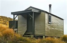
Image: DoC
Scroll down to see a topographical map and road map showing the location of Slaty Hut
[ A ] [ B ] [ C ] [ D ] [ E ] [ F ] [ G ] [ H ] [ I ] [ J ] [ K ] [ L ] [ M ] [ N ] [ O ] [ P ] [ Q ] [ R ] [ S ] [ T ] [ U ] [ V ] [ W ] [ Y ] [ Z ]
Closest 20 Huts to Slaty Hut
These are as the crow fliesStarveall Hut 4.34km Old Man Hut 4.4km Mt Rintoul Hut 6.1km Browning Hut 7.98km Hacket Hut 8.2km Richmond Saddle Hut 8.83km Lake Chalice Hut 9.79km Roebuck Hut 10.49km Mid Goulter Hut 11.16km Mt Fell Hut 11.77km Tarn Hut 11.78km Rocks Hut 14.62km Middy Creek Hut 14.75km Mid Wairoa Hut 16.15km Lower Goulter Hut 16.5km Dun Shelter 17.6km Captain Creek Hut 18.01km Fishtail Hut 18.12km Third House Shelter 18.22km Top Wairoa Hut 21.9km Devils Creek Hut 26.06km Hunters Hut 26.2km Hidden Hut 28.31km Turkeys Nest Bivouac 29.32km Porters Creek Hut 29.94km Fosters Hut 30.79km Chimney 31.88km Gosling Hut 31.94km Boulder Forks Hut 33.92km Mt Sunday Bivouac 34.44km Red Hills Hut 36.26km Caves Hut 36.43km Beebys Hut 38.85km Silverstream Bivouac 39.52km McNaughts Hut 41.53km Greigs Hut 41.61km Top Whare 41.77km Blue Mountain Hut 42.12km Mid Silverstream Hut 42.34km Barbers Hut 43.01km