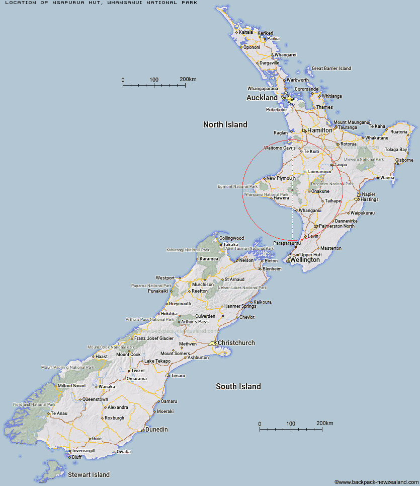
Topo Map showing location of Ngapurua Hut
This information is sourced from DoC, LINZ and Openstreetmap. Some of the hut photos are mine and the rest are from DoC. I will be adding an upload feature soon so people can photos of .Ngapurua Hut.
Basic info: serviced 10 bunk hut in the Whanganui region.
Latitude: -39.3708739791
Longitude: 174.908399051
Location: Whanganui National Park
Area: Manawatu/Whanganui
Type of Hut: Serviced
Tracks: MatemateÄonga Track
Map: BJ32 Topo Map | Road Map
Does this hut still exist? Have any more information? Contact
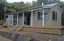
Image: DoC
Scroll down to see a topographical map and road map showing the location of Ngapurua Hut
[ A ] [ B ] [ C ] [ D ] [ E ] [ F ] [ G ] [ H ] [ I ] [ J ] [ K ] [ L ] [ M ] [ N ] [ O ] [ P ] [ Q ] [ R ] [ S ] [ T ] [ U ] [ V ] [ W ] [ Y ] [ Z ]
Closest 20 Huts to Ngapurua Hut
These are as the crow fliesPouri Hut 6.16km Puketotara Hut 6.32km Tieke Kainga 8.17km Puteore Hut 10.21km Tahupo Hut 13.43km Omaru Hut 14.73km John Coull Hut 15.29km Trains Hut 19.51km Ohuraiti Hut 36.74km Downes hut 43.91km Rerekapa Hut 51.16km Mangaturuturu Hut 51.69km Lupton Hut 52.94km Blyth Hut 53.2km Whakapapaiti Hut 54.47km Mangaehuehu Hut 55.25km Whangaehu Hut 59.33km Ten Man Hut 60.92km Rangipo Hut 62.03km Mangatepopo Hut 64.38km Old Waihohonu Hut 68.18km Waihohonu Hut 68.77km Waingongoro Hut 68.86km Maketawa Hut 70.32km Ketetahi Shelter 70.47km Hooker Shelter 70.82km Oturere Hut 71.24km Kaiauai Shelter 72.35km Syme Hut 72.77km Lake Dive Hut 72.99km Zekes Hut 74.43km Holly Hut 74.99km Pouakai Hut 76.44km Kahui Hut 77.35km Waiaua Gorge Hut 77.96km Westlawn Hut 82km Waiweranui Trust Hut 82.58km Hauhungaroa Hut 86.87km Bob's Hut 92.41km Waipakihi Hut 94.48km