Topo Map showing location of Ngamoko Hut
This information is sourced from DoC, LINZ and Openstreetmap. Some of the hut photos are mine and the rest are from DoC. I will be adding an upload feature soon so people can photos of .Ngamoko Hut.
Basic info: standard six-bunk hut in the Manawatu, maintained by the Palmerston North Tramping and Mountaineering club.
Latitude: -40.0353890891
Longitude: 176.052953608
Location: Ruahine Forest Park
Area: Manawatu/Whanganui
Type of Hut: Standard
Tracks: Knights Track to Pohangina Valley East Road
Map: BL36 Topo Map | Road Map
Does this hut still exist? Have any more information? Contact
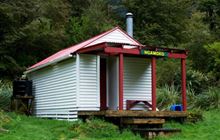
Image: DoC
Scroll down to see a topographical map and road map showing the location of Ngamoko Hut

[ A ] [ B ] [ C ] [ D ] [ E ] [ F ] [ G ] [ H ] [ I ] [ J ] [ K ] [ L ] [ M ] [ N ] [ O ] [ P ] [ Q ] [ R ] [ S ] [ T ] [ U ] [ V ] [ W ] [ Y ] [ Z ]
Closest 20 Huts to Ngamoko Hut
These are as the crow fliesMid Pohangina Hut 2.56km Piripiri Hut 3.1km Cattle Creek Hut 3.52km Leon Kinvig Hut 4km Stanfield Hut 5.87km Toka Bivouac 6.04km Makaretu Hut 6.49km Traverse (A Frame) Hut 8.64km Happy Daze Hut 8.66km Top Gorge Hut 8.75km Alice Nash Memorial Heritage Lodge 9.45km Awatere Hut 10.24km Diggers Hut 11.01km Longview Hut 11.05km Iron Gate Hut 12.06km Forks Hut 12.98km Te Ekaou Hut 13.57km Triangle Hut 14.69km Daphne Hut 15.66km Howletts Hut 15.85km Rangiwahia Hut 16.34km Tarn Bivouac 18.58km Pourangaki Hut 19.8km Kiritaki Hut 20.46km Kelly Knight Hut 20.6km Hinerua Hut 21.72km Smiths Stream Hut 23km Waterfall Hut 23.54km Purity Hut 23.92km Waikamaka Hut 25.82km Waipawa Forks Hut 28.3km McKinnon Hut 28.44km Sunrise Hut 29.26km Triplex Hut 29.62km Crow Hut 29.97km Top Maropea Hut 30.37km Kawhatau Base 30.61km Wakelings Hut 31.9km Gold Creek Hut 32.81km Norris Hut 33.61km