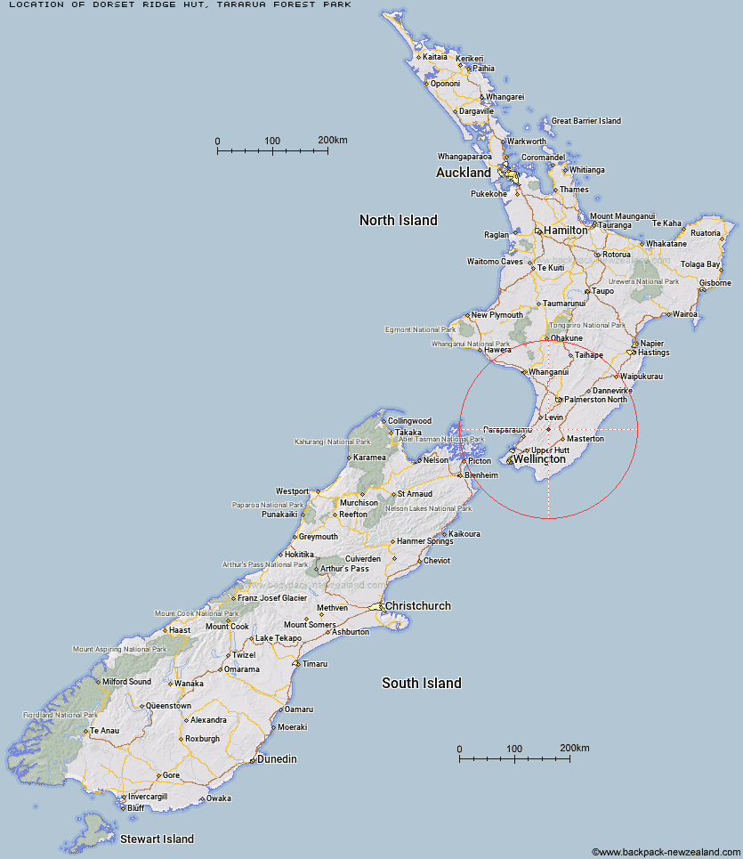
Topo Map showing location of Dorset Ridge Hut
This information is sourced from DoC, LINZ and Openstreetmap. Some of the hut photos are mine and the rest are from DoC. I will be adding an upload feature soon so people can photos of .Dorset Ridge Hut.
Basic info: standard six-bunk hut in the Wairarapa region.
Latitude: -40.8075548746
Longitude: 175.422412184
Location: Tararua Forest Park
Area: Wairarapa
Type of Hut: Standard
Map: BN34 Topo Map | Road Map
Does this hut still exist? Have any more information? Contact
Basic info: standard six-bunk hut in the Wairarapa region.
Latitude: -40.8075548746
Longitude: 175.422412184
Location: Tararua Forest Park
Area: Wairarapa
Type of Hut: Standard
Map: BN34 Topo Map | Road Map
Does this hut still exist? Have any more information? Contact
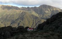
Image: DoC
Scroll down to see a topographical map and road map showing the location of Dorset Ridge Hut
[ A ] [ B ] [ C ] [ D ] [ E ] [ F ] [ G ] [ H ] [ I ] [ J ] [ K ] [ L ] [ M ] [ N ] [ O ] [ P ] [ Q ] [ R ] [ S ] [ T ] [ U ] [ V ] [ W ] [ Y ] [ Z ]
Closest 20 Huts to Dorset Ridge Hut
These are as the crow fliesTarn Ridge Hut 2.19km Carkeek Hut 2.92km McGregor Bivouac 2.96km Mid King Bivouac 3.11km Nichols Hut 3.92km Dracophyllum Hut 5.05km Mitre Flats Hut 5.39km Jumbo Hut 5.4km Arete Forks Hut 5.48km Arete Hut 6.68km Cow Creek Hut 6.71km Anderson Memorial Hut 7.07km Atiwhakatu Hut 7.25km Te Matawai Hut 8.04km Mid Waiohine Hut 8.15km Blue Range Hut 8.26km Powell Hut 8.59km Mountain House Shelter 9.71km Waitewaewae Hut 10.12km South Ohau Hut 10.33km Waiopehu Hut 10.58km Aokaparangi Hut 10.73km Dundas Hut 10.77km Cattle Ridge Hut 11km Roaring Stag Hut 12.13km North Ohau Hut 12.41km Mangahao Flats Hut 12.92km Maungahuka Hut 13.82km Totara Flats Hut 14.01km Neill Forks Hut 15km Herepai Hut 15.39km Penn Creek Hut 15.5km Sayer Hut 15.63km Waikawa Shelter 17.64km Field Hut 17.88km Kime Hut 19.67km Cone Hut 21.02km Waiohine Shelter 22.4km Burn Hut 22.66km Alpha Hut 23.07km