Topo Map showing location of Deep Creek Hut
This information is sourced from DoC, LINZ and Openstreetmap. Some of the hut photos are mine and the rest are from DoC. I will be adding an upload feature soon so people can photos of .Deep Creek Hut.
Basic info: basic six-bunk hut in the Wanaka/Makarora area.
Latitude: -42.8267140884
Longitude: 172.20564491
Location: Pisa Conservation Area
Area: Otago
Type of Hut: Basic/bivvies
Tracks: Pisa Conservation Area tramping tracks
Map: CB12 Topo Map | Road Map
Does this hut still exist? Have any more information? Contact
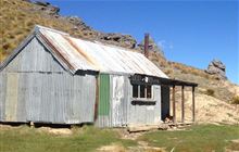
Image: DoC
Scroll down to see a topographical map and road map showing the location of Deep Creek Hut

[ A ] [ B ] [ C ] [ D ] [ E ] [ F ] [ G ] [ H ] [ I ] [ J ] [ K ] [ L ] [ M ] [ N ] [ O ] [ P ] [ Q ] [ R ] [ S ] [ T ] [ U ] [ V ] [ W ] [ Y ] [ Z ]
Closest 20 Huts to Deep Creek Hut
These are as the crow fliesBush Camp Hut 4.29km Esk Bivouac 7.77km Anderson's Hut 9.23km Ant Stream Bivouac 10.01km Lake Mason Hut 10.3km Stony Stream Hut 11.06km North Esk Hut 11.47km Seldom Inn Hut 11.65km Ant Stream Hut 12.31km Cattle Creek Hut 12.52km Gabriel Hut 13.59km South Branch Research Hut 13.65km Lake Sumner Hut 14.08km Anna Hut 14.65km Candlesticks Bivouac 14.84km Jollie Brook Hut 15.82km Hurunui Hut 16.34km Cold Stream Hut 17.09km Evangeline Bivouac 17.12km Upper South Branch Hurunui Hut 19.15km Three Mile Stream Hut 19.31km Glenrae Hut 19.87km Lochinvar Hut 20.11km Bull Creek Hut 20.7km Youngman Stream Hut 22.16km Museum Hut 22.19km Hurunui No 3 Hut 22.62km Mackenzie Bivouac 22.89km Tarn Hut 24.03km Glenrae Bivouac 24.28km Camerons Hut 24.38km Hope Halfway Hut 24.64km Saint Jacob's Hut 24.79km Mackenzie Hut 25.04km Ranger Bivouac 25.41km Top Hope Hut 26.46km Tommys Cabin 26.7km Harper Pass Bivouac 27.64km Lilburne Hut 28.08km Turnbull Bivouac 28.16km