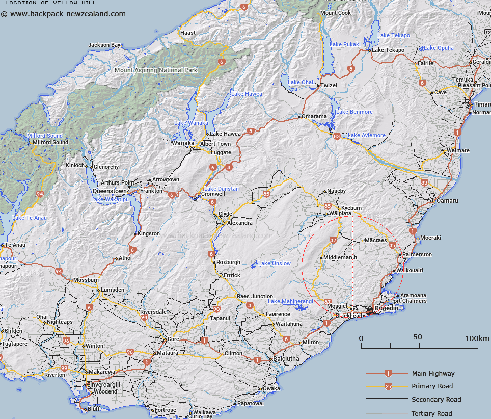
Map showing location of Yellow Hill


LINZ description: Hill at height 718m, site of trig K Yellow Hill, approximately 25km west and inland of Waikouaiti.
Latitude: -45.56806
Longitude: 170.356547
Northing: 4950543
Easting: 1393725.8
Land District: Otago
Feat Type: Hill


Scroll down to see a more detailed road map and below that a topographical map showing the location of Yellow Hill. The road map has been supplied by openstreetmap and the topographical map of Yellow Hill has been supplied by Land Information New Zealand (LINZ).

Yes you can use the top static map for you school/university project or personal website with a link back. Contact me for any commercial use.

Yellow Hill Map New Zealand


New Zealand places in our database
[ A ] [ B ] [ C ] [ D ] [ E ] [ F ] [ G ] [ H ] [ I ] [ J ] [ K ] [ L ] [ M ] [ N ] [ O ] [ P ] [ Q ] [ R ] [ S ] [ T ] [ U ] [ V ] [ W ] [ X ] [ Y ] [ Z ]


Closest 20 Hills to Yellow Hill

Mount Piri ( 2.19km )   Hummock ( 2.75km )   Peat Moss Hills ( 3.07km )   Swampy Hill ( 7.61km )   Little Peak ( 7.74km )   Mount Royal ( 8.01km )   Black Rock ( 8.02km )   Mount Stoker ( 8.9km )   Stoney Hill ( 10.04km )   Mount Scott ( 10.08km )   Bald Hill ( 10.42km )   Mount Thomson ( 10.78km )   Little Hummock ( 10.78km )   Mount Paul ( 10.92km )   Scratchback Hill ( 10.97km )   Ram Rock ( 11.3km )   Slip Hill ( 11.62km )   Brothers Peak ( 12.89km )   Mount Ross ( 13.13km )   Lamb Hill ( 13.59km )   Mount Misery ( 13.74km )   Lots Wife ( 13.93km )   The Sisters ( 13.94km )   Conical Hill ( 14.17km )   Castle Hill ( 14.69km )   Shark Hill ( 15.92km )   Mount Watkin/Hikaroroa ( 16.84km )   Mount Watkins ( 16.84km )   Mount Watkin ( 16.84km )   Mount MacKenzie/Pakihiwitahi ( 17.21km )   Mount Mackenzie ( 17.21km )   Garthmyl Hill ( 17.96km )   Mount John ( 17.98km )   Mount Trotter ( 18.23km )   Jones Hill ( 18.6km )   Stag Hill ( 18.9km )   Whites Hill ( 19.1km )   Little Mount Allan ( 19.44km )   Silver Peak ( 19.89km )   Mount Allan ( 19.97km )