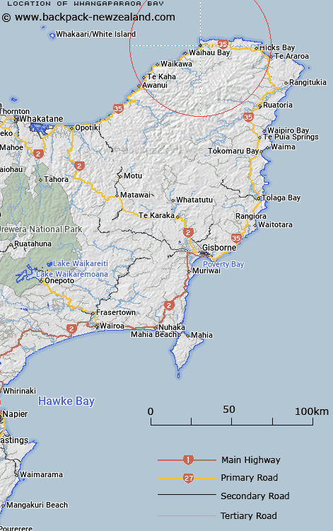
Map showing location of Whangaparaoa Bay


LINZ description: Bay near Cape Runaway in the Bay of Plenty, at the Whangaparoa River mouth.
Latitude: -37.577373
Longitude: 177.986066
Northing: 5829371.7
Easting: 2040407
Land District: Gisborne
Feat Type: Bay


Scroll down to see a more detailed road map and below that a topographical map showing the location of Whangaparaoa Bay. The road map has been supplied by openstreetmap and the topographical map of Whangaparaoa Bay has been supplied by Land Information New Zealand (LINZ).

Yes you can use the top static map for you school/university project or personal website with a link back. Contact me for any commercial use.

Whangaparaoa Bay Map New Zealand


New Zealand places in our database
[ A ] [ B ] [ C ] [ D ] [ E ] [ F ] [ G ] [ H ] [ I ] [ J ] [ K ] [ L ] [ M ] [ N ] [ O ] [ P ] [ Q ] [ R ] [ S ] [ T ] [ U ] [ V ] [ W ] [ X ] [ Y ] [ Z ]


Closest 20 Bays to Whangaparaoa Bay

Kopongatahi Bay ( 1.99km )   Taungawaka Bay ( 3.4km )   Pohueuorau Bay ( 3.58km )   Te Rangiharu Bay ( 5.4km )   Waihau Bay ( 7.78km )   Waiaka Bay ( 13.99km )   Papatea Bay ( 15.5km )   Maraehako Bay ( 19.44km )   Whanarua Bay ( 20.59km )   Oreteiti Bay ( 24.82km )   Taongeiho Bay ( 25.81km )   Tangaihe Bay ( 25.81km )   Onepoto Bay ( 27.96km )   Hicks Bay ( 28.08km )   Kapokapo Bay ( 29.34km )   Maraetai Bay ( 31.68km )   Paengaroa Bay ( 37.52km )   Paingaroa Bay ( 37.52km )   Omaio Bay ( 39.79km )   Whitianga Bay ( 44.67km )   Whituare Bay ( 54.04km )   Whareponga Bay ( 55.71km )   Waipiro Bay ( 58.81km )   Tokomaru Bay ( 69.56km )   Crater Bay ( 70.31km )   Te Awapuia Bay ( 70.31km )   Sulphur Bay ( 70.31km )   Pakihikura Bay ( 71.22km )   Anaura Bay ( 79.21km )   Kaiaua Bay ( 87.06km )   Karaka Bay ( 89.97km )   Ohiwa Harbour ( 90.94km )   Tolago Bay ( 92.63km )   Tologa Bay ( 92.63km )   Tolaga Bay ( 92.63km )   Cook's Cove ( 94.22km )   Otarawairere Bay ( 94.47km )   Sulphur Bay ( 94.93km )   Boulder Bay ( 95.12km )   Waihau Bay ( 101.11km )