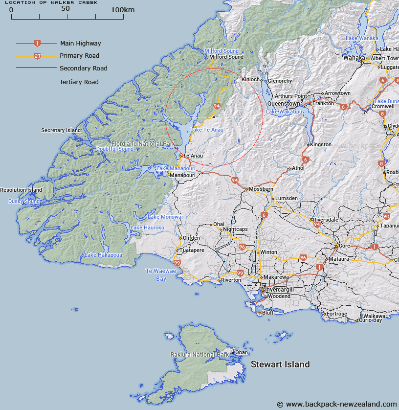
Map showing location of Walker Creek


LINZ description: Stream rising in the Countess Range between Countess and Winton Peaks, and flowing into Eglinton River 2km downriver from Boyd Creek. Crossed by the Te Anau - Milford road, 48.0km from Te Anau.
Latitude: -45.122582
Longitude: 167.979353
Northing: 4991157.2
Easting: 1205142.8
Land District: Southland
Feat Type: Stream


Scroll down to see a more detailed road map and below that a topographical map showing the location of Walker Creek. The road map has been supplied by openstreetmap and the topographical map of Walker Creek has been supplied by Land Information New Zealand (LINZ).

Yes you can use the top static map for you school/university project or personal website with a link back. Contact me for any commercial use.

Walker Creek Map New Zealand


New Zealand places in our database
[ A ] [ B ] [ C ] [ D ] [ E ] [ F ] [ G ] [ H ] [ I ] [ J ] [ K ] [ L ] [ M ] [ N ] [ O ] [ P ] [ Q ] [ R ] [ S ] [ T ] [ U ] [ V ] [ W ] [ X ] [ Y ] [ Z ]


Closest 20 Streams to Walker Creek

Walker Creek ( 0km )   Boyd Creek ( 2.44km )   Eglinton River ( 4.29km )   Mackay Creek ( 4.95km )   Dunton Creek ( 8.01km )   Annear Creek ( 9.05km )   Black Creek ( 10.02km )   Retford Stream ( 11.57km )   Wesney Creek ( 13.55km )   Winton Burn ( 13.59km )   Windon Burn ( 13.59km )   West Burn ( 15.46km )   Kiosk Creek ( 15.55km )   Nurse Creek ( 16.05km )   Eglinton River East Branch ( 16.98km )   Eglinton River West Branch ( 17.61km )   Billy Burn ( 18.04km )   Henry Creek ( 18.05km )   Upukerora River ( 18.62km )   Smithy Creek ( 19.39km )   Murcott Burn ( 19.53km )   Fifteen Mile Creek ( 19.59km )   Mararoa River ( 20.42km )   Tertiary Creek ( 20.52km )   Pond Burn ( 22.12km )   Narrows Creek ( 22.44km )   Glade Burn ( 22.82km )   Saints Creek ( 22.9km )   Mid Burn ( 23.16km )   Von River North Branch ( 23.32km )   Waterfall Creek ( 23.33km )   Lugar Burn ( 23.38km )   Hen Burn ( 23.51km )   Plato Creek ( 23.93km )   Boundary Creek ( 24.57km )   Trench Burn ( 24.62km )   Hut Creek ( 25.19km )   Newton Creek ( 25.25km )   Path Burn ( 25.33km )   Pass Burn ( 25.36km )