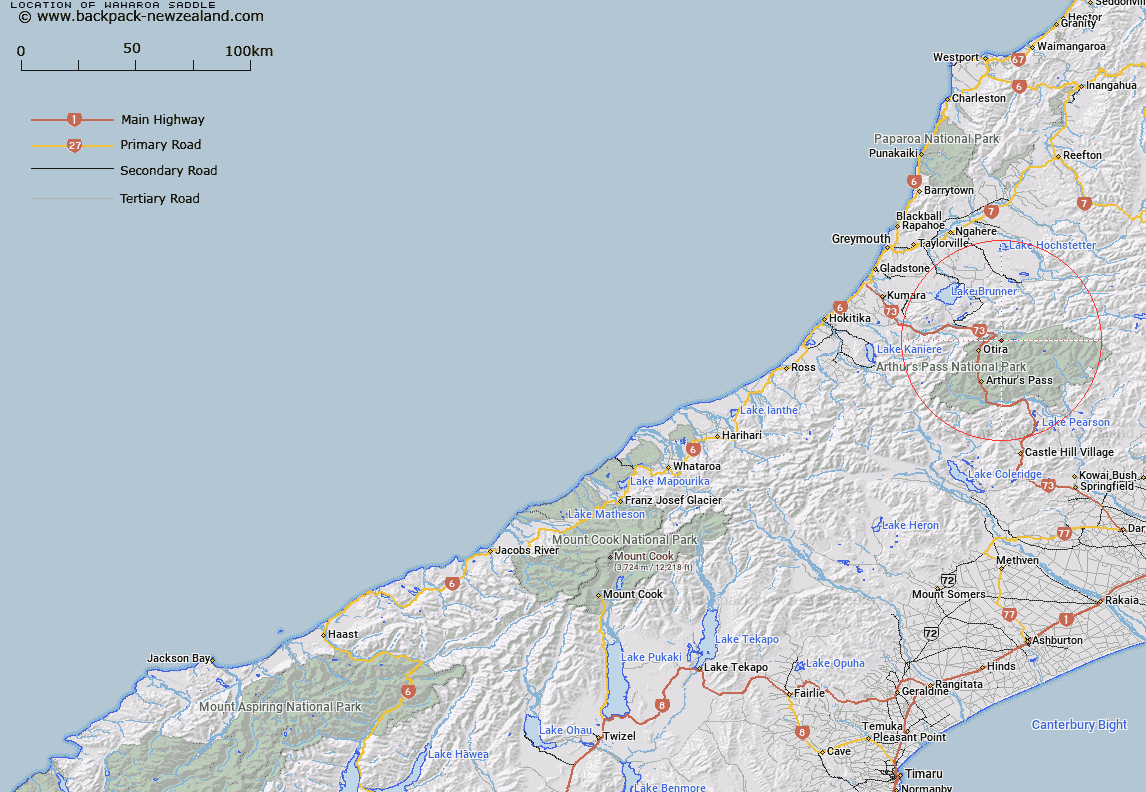
Map showing location of Waharoa Saddle


LINZ description: Saddle between the Paratu and Pfeifer Streams, 500m South of One Shot Hill. Block VII Otira Survey District.
Latitude: -42.794154
Longitude: 171.645154
Northing: 5261153.6
Easting: 1489200
Land District: Westland
Feat Type: Pass


Scroll down to see a more detailed road map and below that a topographical map showing the location of Waharoa Saddle. The road map has been supplied by openstreetmap and the topographical map of Waharoa Saddle has been supplied by Land Information New Zealand (LINZ).

Yes you can use the top static map for you school/university project or personal website with a link back. Contact me for any commercial use.

Waharoa Saddle Map New Zealand


New Zealand places in our database
[ A ] [ B ] [ C ] [ D ] [ E ] [ F ] [ G ] [ H ] [ I ] [ J ] [ K ] [ L ] [ M ] [ N ] [ O ] [ P ] [ Q ] [ R ] [ S ] [ T ] [ U ] [ V ] [ W ] [ X ] [ Y ] [ Z ]


Closest 20 Passs to Waharoa Saddle

Kelly Saddle ( 7.63km )   Worsley Pass ( 10.34km )   Rover Saddle ( 11.02km )   Tarn Col ( 11.19km )   Taruahuna Pass ( 11.3km )   Hunt Saddle ( 11.73km )   Goat Pass ( 12.16km )   Walker Pass ( 12.54km )   Trudge Col ( 13.05km )   Amber Col ( 13.14km )   Temple Col ( 13.22km )   Minchin Pass ( 13.61km )   Arthur's Pass ( 14.39km )   Koeti Pass ( 15.81km )   Waimakariri Col ( 16.47km )   Penny Pass ( 16.67km )   Trent Saddle ( 16.74km )   Williams Saddle ( 17.07km )   Foy Pass ( 17.53km )   Bijleveld Col ( 18.32km )   Scottys Saddle ( 19.64km )   Campbell Pass ( 20.09km )   Dunn Saddle ( 20.28km )   Newton Saddle ( 20.41km )   Casey Saddle ( 20.63km )   Harper Pass ( 20.68km )   Hura Saddle ( 21.32km )   Cox Saddle ( 21.66km )   Harman Pass ( 24.29km )   Goldney Saddle ( 25.82km )   Roche Pass ( 26.54km )   Whitehorn Pass ( 26.87km )   Popes Pass ( 27.69km )   Binser Saddle ( 28.18km )   Styx Saddle ( 28.68km )   Lagoon Saddle ( 28.72km )   White Col ( 29.91km )   Browning Pass ( 30.02km )   Browning Pass/Noti Raureka ( 30.02km )   Kawhaka Pass ( 30.1km )