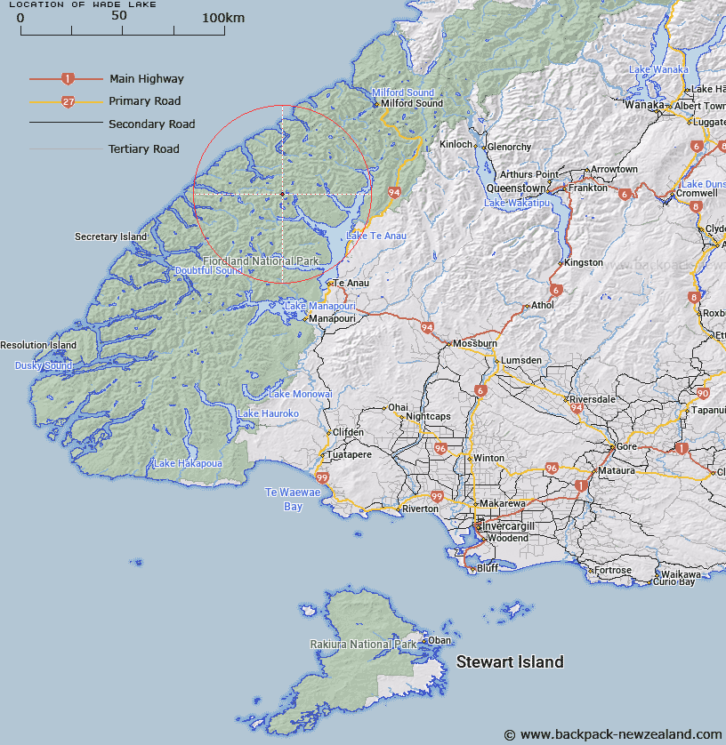
Map showing location of Wade Lake


LINZ description: Lake between George Sound and Middle Fiord of Lake Te Anau, south-west of and draining into Lake Thompson
Latitude: -45.042145
Longitude: 167.518406
Northing: 4997731.8
Easting: 1168284.2
Land District: Southland
Feat Type: Lake


Scroll down to see a more detailed road map and below that a topographical map showing the location of Wade Lake. The road map has been supplied by openstreetmap and the topographical map of Wade Lake has been supplied by Land Information New Zealand (LINZ).

Yes you can use the top static map for you school/university project or personal website with a link back. Contact me for any commercial use.

Wade Lake Map New Zealand


New Zealand places in our database
[ A ] [ B ] [ C ] [ D ] [ E ] [ F ] [ G ] [ H ] [ I ] [ J ] [ K ] [ L ] [ M ] [ N ] [ O ] [ P ] [ Q ] [ R ] [ S ] [ T ] [ U ] [ V ] [ W ] [ X ] [ Y ] [ Z ]


Closest 20 Lakes to Wade Lake

Lake Thomson ( 1.64km )   Lake Clark ( 2.22km )   Deadwood Lagoon ( 3.61km )   Lake Hankinson ( 4.68km )   Lake Ogle ( 4.81km )   Lake Wapiti ( 6.09km )   Lake Sutherland ( 6.13km )   Lake McIvor ( 6.42km )   Lake Katherine ( 7.6km )   Lake Alice ( 8.98km )   Welcome Lake ( 11.17km )   Lake Roxburgh ( 13.25km )   Lake Mackinnon ( 13.28km )   Bloxham Lake ( 13.33km )   Lake Marchant ( 15.13km )   Lake Beddoes ( 15.23km )   Myth Tarn ( 15.67km )   Tawera Tarn ( 18.37km )   Three Duck Lake ( 18.62km )   Lake Wisely ( 20.06km )   Lake Bernard ( 20.07km )   Lake Shirley ( 21.12km )   Shirley Lake ( 21.31km )   Lake Duncan ( 22.86km )   Lake Brownlee ( 23.32km )   Eyles Lake ( 23.43km )   Swan Mere ( 23.91km )   Lake Sumor ( 24.69km )   Lake Te Au ( 25.94km )   Lake Grave ( 26.1km )   Lake Hilda ( 27.96km )   Lake Te Anau ( 28.09km )   Hidden Lake ( 28.1km )   Bog Lake ( 28.31km )   Lake Ione ( 29.76km )   Orbell Lake ( 30.29km )   Lake Eva ( 30.36km )   Lake Hall ( 30.42km )   Lake Quill ( 30.52km )   Hidden Lake ( 31.26km )