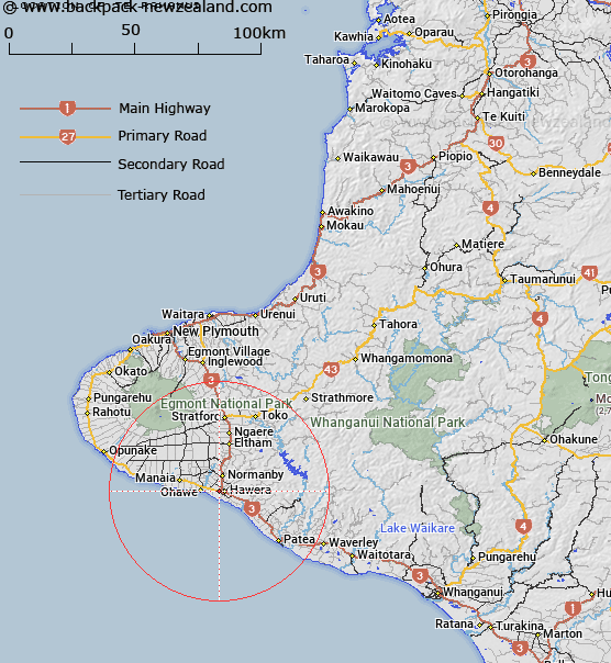
Map showing location of Te Ramanui


LINZ description: Found in in the west of the Hawera locality, east of Waihi Stream. Location NZMS 260 Q21, Grid Reference 188 790
Latitude: -39.587548
Longitude: 174.265749
Northing: 5617254.2
Easting: 1708692.9
Land District: Taranaki
Feat Type: Site


Scroll down to see a more detailed road map and below that a topographical map showing the location of Te Ramanui. The road map has been supplied by openstreetmap and the topographical map of Te Ramanui has been supplied by Land Information New Zealand (LINZ).

Yes you can use the top static map for you school/university project or personal website with a link back. Contact me for any commercial use.

Te Ramanui Map New Zealand


New Zealand places in our database
[ A ] [ B ] [ C ] [ D ] [ E ] [ F ] [ G ] [ H ] [ I ] [ J ] [ K ] [ L ] [ M ] [ N ] [ O ] [ P ] [ Q ] [ R ] [ S ] [ T ] [ U ] [ V ] [ W ] [ X ] [ Y ] [ Z ]


Closest 20 Sites to Te Ramanui

Taupatatea Pa ( 2.45km )   Turuturu Mokai Pa ( 2.92km )   Ketemarae Pa ( 4km )   Taiporohenui Marae ( 4.87km )   Te Ruaki Pa ( 6.07km )   Ohangai Pa ( 6.11km )   Okahutiti Pa ( 6.82km )   Otopawa Pa ( 7.39km )   Wharepuni Pa ( 7.87km )   Mawhitiwhiti Pa ( 8.16km )   Aotearoa Pa ( 8.92km )   Waimate ( 9.22km )   Orangi Tuapeka ( 9.71km )   Inmans Redoubt ( 10.12km )   Manawapou Pa ( 10.69km )   Thackers Redoubt ( 10.88km )   Araukuku Pa ( 10.97km )   Te Aroha Marae ( 10.98km )   Manaia Redoubt ( 12.21km )   Kaihuahua Pa ( 12.97km )   Manutahi Marae ( 14.98km )   Pariroa Marae ( 23.18km )   Whitikau ( 23.3km )   Maraeroa ( 25.82km )   Waioturi Marae ( 27.64km )   Whakaahu Rangi Plaque ( 28.78km )   Whakatukorau ( 29.56km )   Papaka Te Rangi ( 32.79km )   Te Namu Pa ( 39.71km )   Waipapa Marae ( 44.26km )   Ihupuku Marae ( 47km )   Parihaka Pa ( 49.41km )   Tutahi Marae ( 51.47km )   Takirau Marae ( 51.87km )   Mangahau Pa ( 52.8km )   Hurworth House ( 53.66km )   Patuha Pa ( 53.99km )   Okato Blockhouse ( 54.18km )   Orua Pa ( 55.01km )   Ngaweka Pa ( 55.18km )