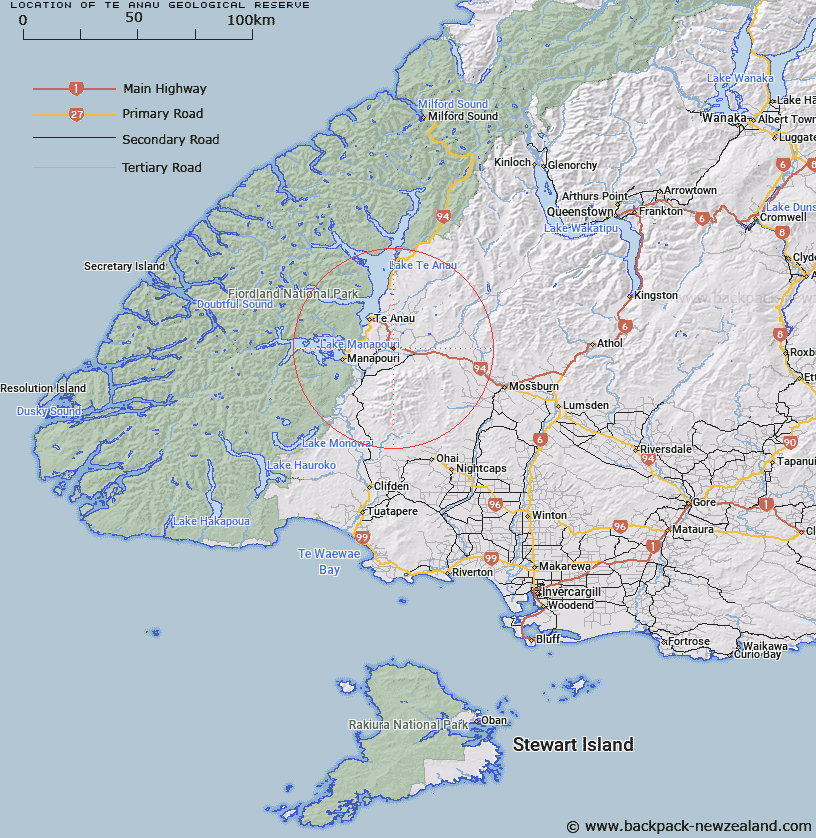
Map showing location of Te Anau Geological Reserve


LINZ description: No details provided by OTS and DOC
Latitude: -45.524444
Longitude: 167.810278
Northing: 4945673.2
Easting: 1194729
Land District: Southland
Feat Type: Scientific Reserve


Scroll down to see a more detailed road map and below that a topographical map showing the location of Te Anau Geological Reserve. The road map has been supplied by openstreetmap and the topographical map of Te Anau Geological Reserve has been supplied by Land Information New Zealand (LINZ).

Yes you can use the top static map for you school/university project or personal website with a link back. Contact me for any commercial use.

Te Anau Geological Reserve Map New Zealand


New Zealand places in our database
[ A ] [ B ] [ C ] [ D ] [ E ] [ F ] [ G ] [ H ] [ I ] [ J ] [ K ] [ L ] [ M ] [ N ] [ O ] [ P ] [ Q ] [ R ] [ S ] [ T ] [ U ] [ V ] [ W ] [ X ] [ Y ] [ Z ]


Closest 20 Scientific Reserves to Te Anau Geological Reserve

The Wilderness Area Scientific Reserve ( 3.47km )   Burwood Bush (Red Tussock) Scientific Reserve ( 19.9km )   Burwood (Takah? Rearing Site) Scientific Reserve ( 20.99km )   Borland Mire Scientific Reserve ( 35.37km )   Clifden Scientific Reserve ( 56.96km )   Otapiri Scientific Reserve ( 70.63km )   Pukerau Red Tussock Scientific Reserve ( 117.03km )   Chapman Road Scientific Reserve ( 123.01km )   Waituna Wetlands Scientific Reserve ( 130.61km )   Mahaka Katia Scientific Reserve ( 132.14km )   Locharburn Scientific Reserve ( 135.99km )   Mata-au Scientific Reserve ( 145.63km )   Lagoon Creek Scientific Reserve ( 152.47km )   Curio Bay Scientific Reserve ( 161.01km )   Black Rock Scientific Reserve ( 162.19km )   Tahakopa Peat Dome Scientific Reserve ( 168.05km )   Otanomomo Scientific Reserve ( 171.86km )   Waiora Scientific Reserve ( 201.61km )   Bendhu Scientific Reserve ( 204.01km )   Every's Scientific Reserve ( 219.81km )   Shag Point Scientific Reserve ( 233.88km )   Shag Point/Matakaea Scientific Reserve ( 233.88km )   Pukaki Scientific Reserve ( 239.42km )   Lake Tekapo Scientific Reserve ( 268.19km )   Ianthe Scientific Reserve ( 355.74km )   Bankside Scientific Reserve ( 397.77km )   Enys Scientific Reserve ( 404.36km )   Waihora Scientific Reserve ( 418.12km )   Kaitorete Spit Scientific Reserve ( 421.41km )   Eyrewell Scientific Reserve ( 421.55km )   Medbury Scientific Reserve ( 488.39km )   Culverden Scientific Reserve ( 507.25km )   White Creek Fault Scientific Reserve ( 546.21km )   Blue Duck Scientific Reserve ( 602.31km )   Chancet Rocks Scientific Reserve ( 656.92km )   Muritai Scientific Reserve ( 668.44km )   Kokorua Open Scientific Reserve ( 675km )   Tom Shand Scientific Reserve ( 701.42km )   Sinclair Head Scientific Reserve ( 724.13km )   Red Rocks Scientific Reserve ( 725.12km )