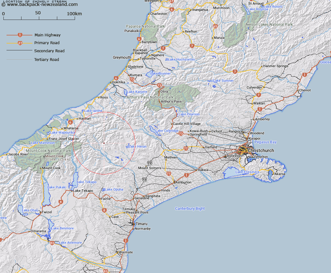
Map showing location of Shingly Stream


LINZ description: Left bank tributary of Lawrence River, rising in the Potts Range, 4km East of Trig. P (Geodetic Code B2Q0), and joining Lawrence River 3.5km upstream of Clyde River. Block VI Clyde Survey District.
Latitude: -43.435207
Longitude: 170.882097
Northing: 5188675.8
Easting: 1428594.4
Land District: Canterbury
Feat Type: Stream


Scroll down to see a more detailed road map and below that a topographical map showing the location of Shingly Stream. The road map has been supplied by openstreetmap and the topographical map of Shingly Stream has been supplied by Land Information New Zealand (LINZ).

Yes you can use the top static map for you school/university project or personal website with a link back. Contact me for any commercial use.

Shingly Stream Map New Zealand


New Zealand places in our database
[ A ] [ B ] [ C ] [ D ] [ E ] [ F ] [ G ] [ H ] [ I ] [ J ] [ K ] [ L ] [ M ] [ N ] [ O ] [ P ] [ Q ] [ R ] [ S ] [ T ] [ U ] [ V ] [ W ] [ X ] [ Y ] [ Z ]


Closest 20 Streams to Shingly Stream

Lawrence River ( 1.7km )   Wildsheep Stream ( 3.1km )   Clyde River ( 5.16km )   Potts River ( 5.21km )   Sinclair River ( 7.26km )   Cattle Creek ( 8.31km )   Caroline Stream ( 8.54km )   Outlaw Creek ( 8.63km )   Moses Creek ( 9.76km )   Argument Creek ( 9.94km )   Stumpy Stream ( 10.12km )   Billy McCoy Creek ( 10.21km )   Cloudy Stream ( 10.47km )   McCoy Stream ( 10.81km )   Powerhouse Stream ( 12.12km )   Frances River ( 12.35km )   Spean Stream ( 12.81km )   Tauroa Creek ( 13.05km )   Kirk Stream ( 13.5km )   Fan Stream ( 14.43km )   Lochaber Stream ( 14.62km )   Emily Creek ( 14.65km )   Lochiel Stream ( 14.9km )   The Growler ( 15km )   Cameron River ( 15.02km )   Agnes Stream ( 15.11km )   Veil Stream ( 15.19km )   Strone Stream ( 15.68km )   Red Moutain Stream ( 15.93km )   Reischek Stream ( 16.03km )   Havelock River ( 16.33km )   Alma Stream ( 16.81km )   Murphy Stream ( 17.21km )   Carneys Creek ( 17.23km )   Sparrow Hawk Stream ( 17.25km )   Coronation Stream ( 17.47km )   St Winifred Stream ( 17.48km )   Craddock Stream ( 17.52km )   Cradock Stream ( 17.52km )   Forbes River ( 17.6km )