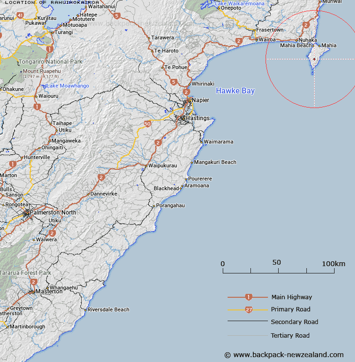
Map showing location of Rahuimokairoa


LINZ description: At 403m height towards the middle south of the Mahia Peninsula.
Latitude: -39.187945
Longitude: 177.881724
Northing: 5651000
Easting: 2021700
Land District: Hawke's Bay
Feat Type: Trig Station


Scroll down to see a more detailed road map and below that a topographical map showing the location of Rahuimokairoa. The road map has been supplied by openstreetmap and the topographical map of Rahuimokairoa has been supplied by Land Information New Zealand (LINZ).

Yes you can use the top static map for you school/university project or personal website with a link back. Contact me for any commercial use.

Rahuimokairoa Map New Zealand


New Zealand places in our database
[ A ] [ B ] [ C ] [ D ] [ E ] [ F ] [ G ] [ H ] [ I ] [ J ] [ K ] [ L ] [ M ] [ N ] [ O ] [ P ] [ Q ] [ R ] [ S ] [ T ] [ U ] [ V ] [ W ] [ X ] [ Y ] [ Z ]


Closest 20 Trig Stations to Rahuimokairoa

Taupiri ( 4.73km )   Putoitoi ( 5.12km )   Putoetoe ( 5.12km )   Puto-oe-a-Patua ( 5.12km )   Moumoukai ( 27.27km )   Whakaumuataneteko ( 33km )   Whakaumuatanetaako ( 33km )   Pukaroronui ( 39.22km )   Rerepi ( 45.96km )   Rarepe ( 45.96km )   Whakapunaki ( 48.95km )   Whakapunake ( 48.95km )   Te Tahi ( 58.23km )   Kohirikiriki ( 65.37km )   Koherekireki ( 65.37km )   Te Aitangaamahaki ( 68.22km )   Te Itanga Mahaki ( 68.22km )   Patuwahine ( 71.05km )   Tapapanui ( 74.03km )   Pukakaramea ( 81.96km )   Pukaramea ( 81.96km )   Patuwahine ( 90.35km )   Ngapukeriki ( 97.76km )   Ngapuketurua ( 97.76km )   Mangahaumia ( 100.53km )   Maungahaumi ( 100.53km )   Maungahunia ( 100.53km )   Waka Atea ( 101.91km )   Wakaateo ( 101.91km )   Te Iwiroa ( 104.52km )   Te Iwi Roa ( 104.52km )   Paripoupou ( 106.03km )   Parepoupou ( 106.03km )   Tutamoe ( 106.25km )   Tutamoi ( 106.25km )   Maporiki ( 107.07km )   Mapouriki ( 107.07km )   Moutohora ( 107.26km )   Motuhora ( 107.26km )   Tawhiti ( 108.39km )