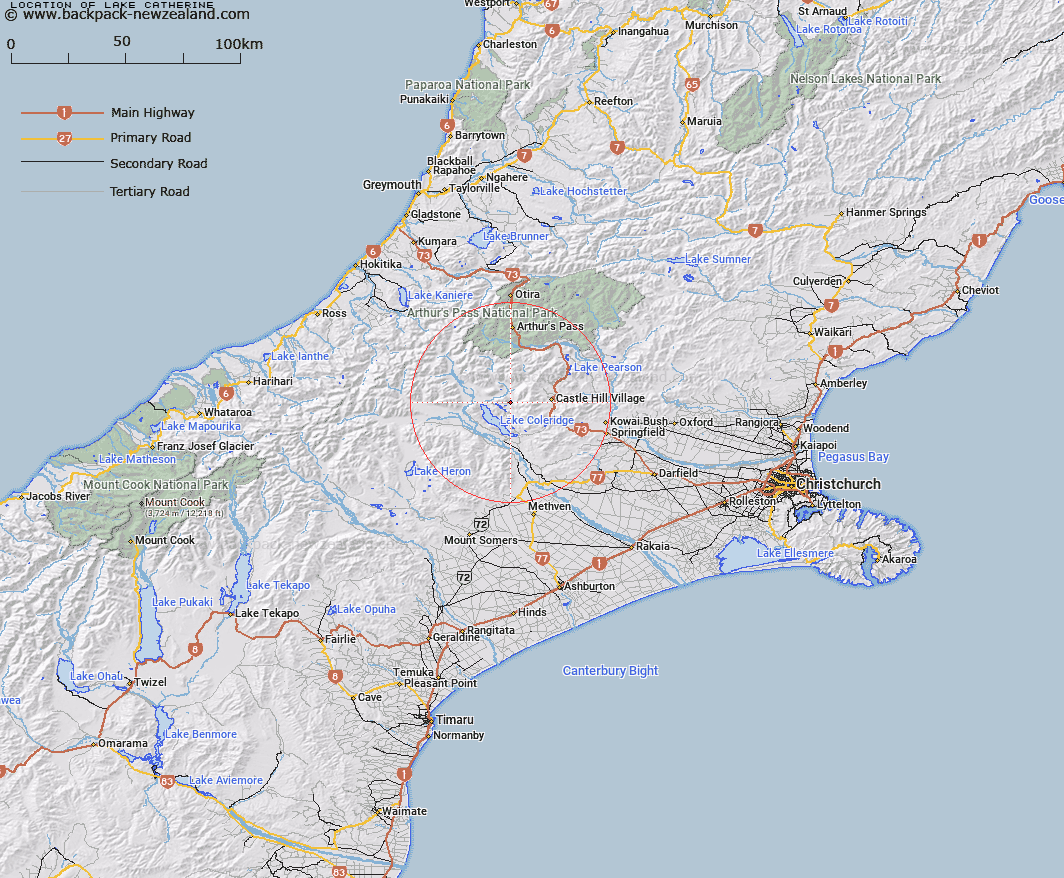
Map showing location of Lake Catherine


LINZ description: Small lake, north east of Lake Ida, runs into Catherine Stream.
Latitude: -43.221955
Longitude: 171.559635
Northing: 5213530
Easting: 1483020.9
Land District: Canterbury
Feat Type: Lake


Scroll down to see a more detailed road map and below that a topographical map showing the location of Lake Catherine. The road map has been supplied by openstreetmap and the topographical map of Lake Catherine has been supplied by Land Information New Zealand (LINZ).

Yes you can use the top static map for you school/university project or personal website with a link back. Contact me for any commercial use.

Lake Catherine Map New Zealand


New Zealand places in our database
[ A ] [ B ] [ C ] [ D ] [ E ] [ F ] [ G ] [ H ] [ I ] [ J ] [ K ] [ L ] [ M ] [ N ] [ O ] [ P ] [ Q ] [ R ] [ S ] [ T ] [ U ] [ V ] [ W ] [ X ] [ Y ] [ Z ]


Closest 20 Lakes to Lake Catherine

Mystery Tarn ( 2.03km )   Lake Ida ( 2.29km )   Lake Evelyn ( 3.83km )   Lake Selfe ( 3.88km )   Lake Henrietta ( 4.89km )   Lake Lilian ( 6.04km )   Lake Coleridge ( 9.14km )   Lake Georgina ( 10.59km )   Red Lakes ( 12.69km )   Lake Lyndon ( 14.47km )   Casey Tarn ( 15.19km )   Lake Pearson ( 22.76km )   Lake Rubicon ( 23.29km )   Lake Grasmere ( 24.79km )   Vagabonds Inn ( 25.8km )   Lake Sarah ( 26.06km )   Lake Marymere ( 26.57km )   Lake Hawdon ( 26.95km )   Blackwater Lake ( 31.88km )   Ariels Tarns ( 33.33km )   Margarets Tarn ( 34.07km )   Lake Browning/Whakarewa ( 35.27km )   Lake Browning ( 35.27km )   Lake Misery ( 35.79km )   Mavis Lake ( 36.24km )   Lake Letitia ( 36.87km )   Quagmire Tarn ( 37.19km )   Windy Tarn ( 37.56km )   Lake Florence ( 38.22km )   Lake Anna ( 39.2km )   Lake Sally ( 39.53km )   Seagull Lake ( 40.86km )   Lake Heron ( 42.73km )   Manuka Lake ( 42.8km )   Lake Emily ( 45.24km )   Lake Lyes ( 45.75km )   Lake Grace ( 47.29km )   Lake Minchin ( 48.53km )   Lake Kaurapataka ( 49.77km )   Maori Lakes ( 49.8km )