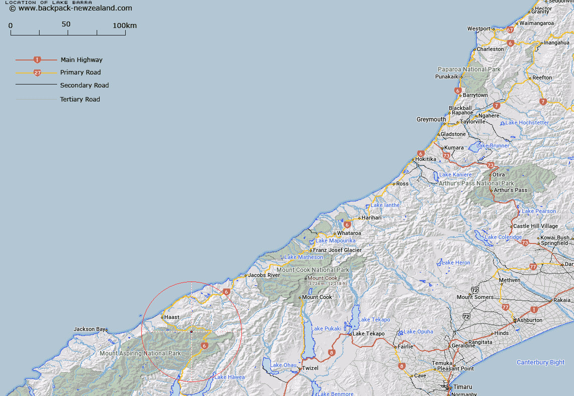
Map showing location of Lake Barra


LINZ description: Small circular lake, about 100-200m in diameter, at the head of Macpherson Creek, a tributary of Haast River, in Mount Aspiring National Park.
Latitude: -43.985128
Longitude: 169.266657
Northing: 5123000
Easting: 1300600
Land District: Westland
Feat Type: Lake


Scroll down to see a more detailed road map and below that a topographical map showing the location of Lake Barra. The road map has been supplied by openstreetmap and the topographical map of Lake Barra has been supplied by Land Information New Zealand (LINZ).

Yes you can use the top static map for you school/university project or personal website with a link back. Contact me for any commercial use.

Lake Barra Map New Zealand


New Zealand places in our database
[ A ] [ B ] [ C ] [ D ] [ E ] [ F ] [ G ] [ H ] [ I ] [ J ] [ K ] [ L ] [ M ] [ N ] [ O ] [ P ] [ Q ] [ R ] [ S ] [ T ] [ U ] [ V ] [ W ] [ X ] [ Y ] [ Z ]


Closest 20 Lakes to Lake Barra

Lake Eggeling ( 9.66km )   Lake Douglas ( 14.27km )   Lake Dime ( 17.69km )   Lake Law ( 19.48km )   Tawharekiri Lakes ( 22.36km )   Boil Hole ( 22.44km )   Lake Sweeney ( 24.96km )   Lake Topsy ( 25.3km )   Lake Moeraki ( 28.26km )   Macs Lagoon ( 28.66km )   Crucible Lake ( 29.63km )   Lake Paringa ( 31.35km )   Lake Rasselas ( 32.79km )   Waiatoto Lagoon ( 37.14km )   Lake Nisson ( 37.98km )   Lake Castalia ( 38.26km )   Charlies Ponds ( 39.35km )   Minim Mere ( 39.41km )   Lake H?wea ( 39.69km )   Lake Hawea ( 39.69km )   Otoko Lake ( 40.2km )   Lake Greaney ( 40.37km )   Lucidus Lake ( 40.72km )   Lucidus Lake ( 40.83km )   Lake Diana ( 42.42km )   Lake Mary ( 44.82km )   Dumb-bell Lake ( 48.77km )   Lake Ellery ( 49.41km )   The Neck Lagoon ( 50.3km )   Lake Leeb ( 50.76km )   Lake Dan ( 51.07km )   Lake Kini ( 51.2km )   Lake Bux ( 52.19km )   Lake Porm ( 52.21km )   Lake Ohau ( 54.33km )   Lake Rototekoiti ( 55.39km )   Lake Roto Te Koeti ( 55.39km )   Disappearing Lake ( 56.18km )   Lake Middleton ( 56.19km )   Cloudmaker Lake ( 56.24km )