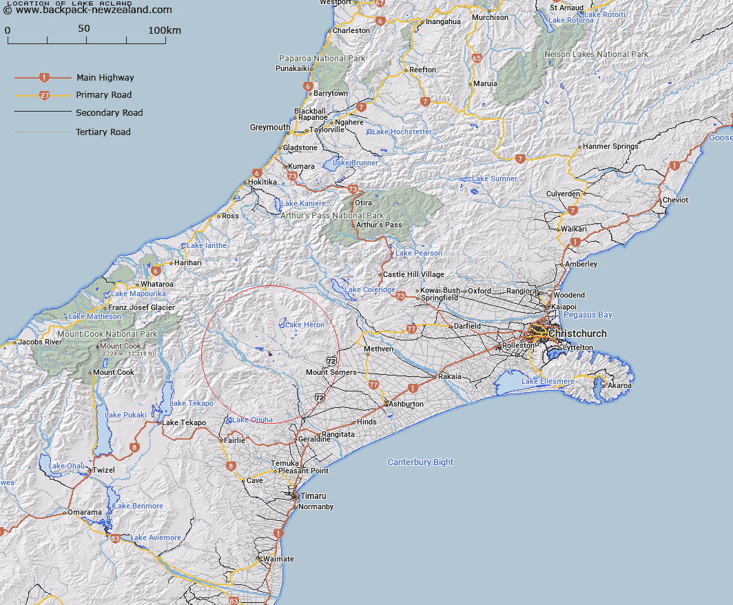
Map showing location of Lake Acland


LINZ description: Lake between the upper Rangitata and Ashburton Rivers 5km North-east of Mount Harper in the Harper Range. Blocks VI and VII, Tripp Survey District.
Latitude: -43.636181
Longitude: 171.106247
Northing: 5166792
Easting: 1447243.9
Land District: Canterbury
Feat Type: Lake


Scroll down to see a more detailed road map and below that a topographical map showing the location of Lake Acland. The road map has been supplied by openstreetmap and the topographical map of Lake Acland has been supplied by Land Information New Zealand (LINZ).

Yes you can use the top static map for you school/university project or personal website with a link back. Contact me for any commercial use.

Lake Acland Map New Zealand


New Zealand places in our database
[ A ] [ B ] [ C ] [ D ] [ E ] [ F ] [ G ] [ H ] [ I ] [ J ] [ K ] [ L ] [ M ] [ N ] [ O ] [ P ] [ Q ] [ R ] [ S ] [ T ] [ U ] [ V ] [ W ] [ X ] [ Y ] [ Z ]


Closest 20 Lakes to Lake Acland

Lake Roundabout ( 2.1km )   Lake Donne ( 3.18km )   Lambies Lagoon ( 3.25km )   Spider Lakes ( 3.44km )   Lake Trinity ( 4.08km )   Lake Denny ( 4.15km )   Lake Camp ( 4.75km )   Lake Howard ( 4.75km )   Howard Lake ( 4.91km )   Lake Clearwater ( 6.13km )   Tripp Lake ( 6.13km )   Maori Lakes ( 9.03km )   Mystery Lake ( 12.32km )   Lake Emily ( 13.77km )   Manuka Lake ( 16.14km )   Seagull Lake ( 17.98km )   Lake Heron ( 17.99km )   Quagmire Tarn ( 34.94km )   Windy Tarn ( 36.66km )   Lake Opuha ( 43.37km )   Lake Coleridge ( 49.76km )   Abel Lake ( 50.15km )   Lake Georgina ( 51.49km )   Phantom Lagoon ( 52.8km )   Red Lakes ( 53.43km )   Rapuwai Lagoon ( 53.82km )   Lake Evelyn ( 55.08km )   Lake Tekapo ( 55.13km )   Lake Selfe ( 55.21km )   Lake Henrietta ( 55.31km )   Reid Lake ( 56.21km )   Ice Lake ( 56.42km )   Lake Ida ( 56.6km )   Ivory Lake ( 58.18km )   Balance Lake ( 58.18km )   Tui Tarn ( 58.82km )   Lake Catherine ( 58.84km )   Lake Murray ( 59.22km )   Stony Tarn ( 59.26km )   Roys Lagoon ( 59.3km )