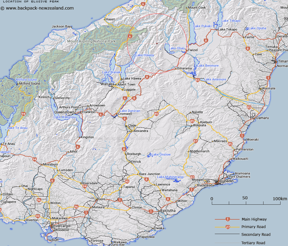
Map showing location of Elusive Peak


LINZ description: Peak at height 2231m in the Barrier Range, less than 2km south south-east of Mount Maitland.
Latitude: -44.17459
Longitude: 169.7176
Northing: 5103495
Easting: 1337605.1
Land District: Otago
Feat Type: Hill


Scroll down to see a more detailed road map and below that a topographical map showing the location of Elusive Peak. The road map has been supplied by openstreetmap and the topographical map of Elusive Peak has been supplied by Land Information New Zealand (LINZ).

Yes you can use the top static map for you school/university project or personal website with a link back. Contact me for any commercial use.

Elusive Peak Map New Zealand


New Zealand places in our database
[ A ] [ B ] [ C ] [ D ] [ E ] [ F ] [ G ] [ H ] [ I ] [ J ] [ K ] [ L ] [ M ] [ N ] [ O ] [ P ] [ Q ] [ R ] [ S ] [ T ] [ U ] [ V ] [ W ] [ X ] [ Y ] [ Z ]


Closest 20 Hills to Elusive Peak

Mount Maitland ( 1.56km )   Hiwiroa Mount ( 3.62km )   Paku Peak ( 4.91km )   Mount Peterson ( 5.66km )   Shingle Hill ( 6.34km )   Mount Stafford ( 7.15km )   Mount Sutton ( 7.29km )   Pakeke Peak ( 8.65km )   Mount Calvin ( 9.17km )   Steeple Peak ( 9.18km )   Pinnacle ( 9.19km )   Mount Barth ( 9.25km )   Mount Wyn Irwin ( 9.69km )   Mount Saint Mary ( 10.52km )   Bruce Peak ( 10.77km )   Mount Heim ( 10.82km )   Belfry Peak ( 10.84km )   Chosspile Peaks ( 11.57km )   Temple Peak ( 11.91km )   Mount Huxley ( 11.95km )   Mount Rigel ( 12.12km )   Ram Hill ( 12.19km )   Abseil Peak ( 13.04km )   College Peak ( 14.53km )   Highlander Peak ( 14.73km )   Rabbiters Peak ( 14.76km )   Stevenson Peak ( 14.86km )   Soloist Peak ( 15.07km )   Protuberance Peak ( 15.32km )   Mount Hammerack ( 15.89km )   Celtic Peak ( 16.4km )   Ohau Peak ( 16.44km )   Mount Ferguson ( 16.95km )   Ben Ohau ( 17.91km )   Anita Peak ( 18.34km )   Mount Glen Lyon ( 18.71km )   Mount Gladwish ( 19.07km )   Leaning Mount ( 19.16km )   Stony Peak ( 19.34km )   Mount Enderby ( 19.42km )