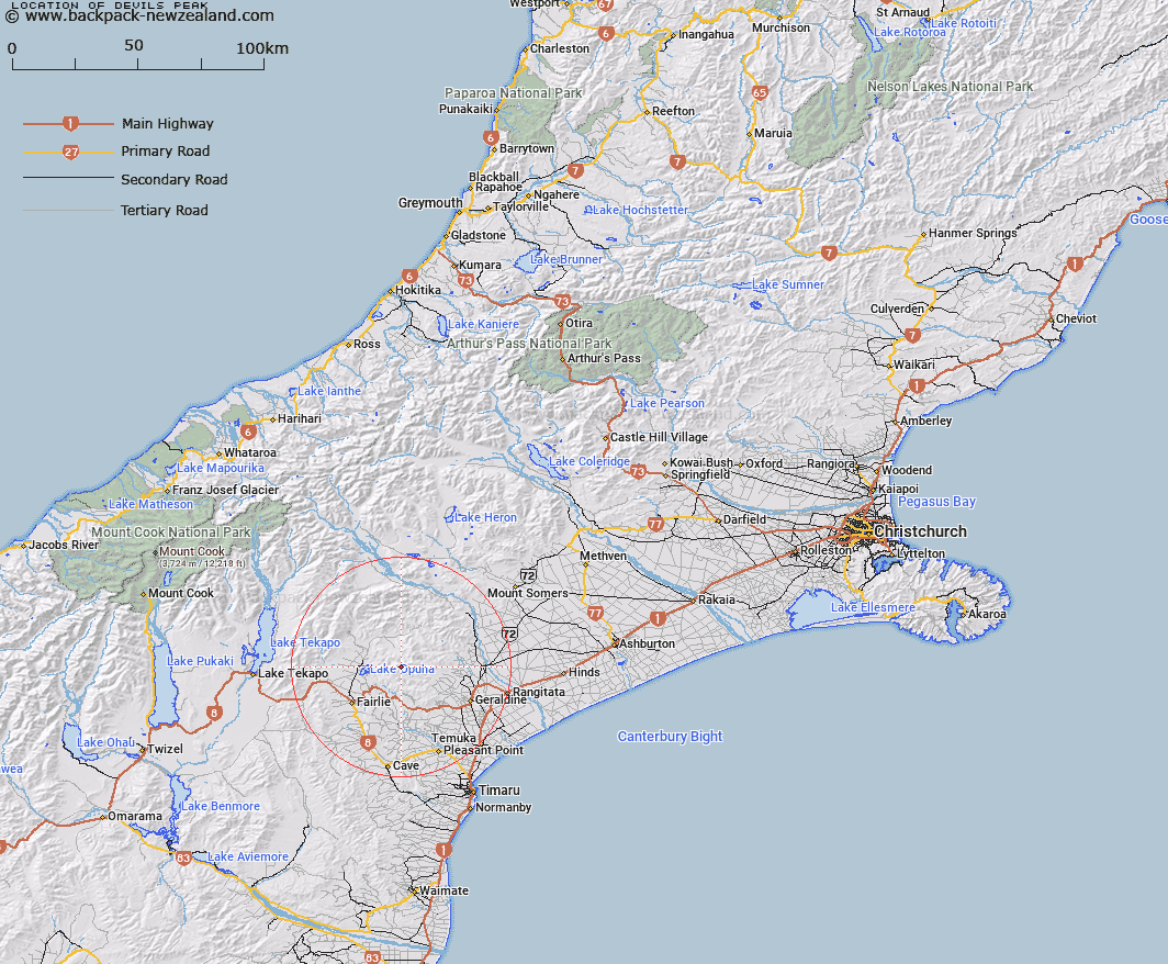
Map showing location of Devils Peak


LINZ description: On Four Peaks Range. Approximately 3.5km south-westerly from Trig. D (Waihi Peak). Four Peaks Survey District.
Latitude: -43.978
Longitude: 171.001236
Northing: 5128628.6
Easting: 1439690.5
Land District: Canterbury
Feat Type: Hill


Scroll down to see a more detailed road map and below that a topographical map showing the location of Devils Peak. The road map has been supplied by openstreetmap and the topographical map of Devils Peak has been supplied by Land Information New Zealand (LINZ).

Yes you can use the top static map for you school/university project or personal website with a link back. Contact me for any commercial use.

Devils Peak Map New Zealand


New Zealand places in our database
[ A ] [ B ] [ C ] [ D ] [ E ] [ F ] [ G ] [ H ] [ I ] [ J ] [ K ] [ L ] [ M ] [ N ] [ O ] [ P ] [ Q ] [ R ] [ S ] [ T ] [ U ] [ V ] [ W ] [ X ] [ Y ] [ Z ]


Closest 20 Hills to Devils Peak

Fiery Peak ( 1.19km )   Mount Walker ( 3.44km )   Waihi Peak ( 3.75km )   Tripps Peak ( 5.47km )   Blue Mountain ( 7.11km )   Sugar Loaf ( 8.03km )   Mount Catherine ( 9.68km )   Ben Hope ( 10.48km )   Mount Edith ( 11.2km )   Round Hill ( 11.84km )   Mount Michael ( 12.77km )   Grants Top ( 12.85km )   Mount Frances ( 13.85km )   Waitohi Hill ( 14.98km )   Kakahu Hill ( 17.81km )   Middle Mount Peel ( 18.96km )   Mount Peel ( 19.22km )   Little Mount Peel ( 20.07km )   Little Mount Peel/Huatekerekere ( 20.07km )   Fox Peak ( 23.38km )   Mount Gay ( 23.86km )   Coal Hill ( 24.73km )   Sugar Loaf ( 25.03km )   Dobson Peak ( 26.94km )   Mount Misery ( 26.94km )   Ben McLeod ( 27.1km )   Mount Maude ( 29.56km )   Neutral Hill ( 29.74km )   Rawtor ( 29.85km )   Mount Musgrave ( 29.92km )   Mount Burgess ( 30.46km )   Mount Ardmore ( 30.99km )   Low Hills ( 31.43km )   Mount Pukanui ( 31.54km )   High Terrace ( 32.41km )   Mount Edward ( 32.43km )   Round Hill ( 32.51km )   Wee McGregor ( 33.7km )   Cairn Hill ( 34.44km )   Mount Tripp ( 35.05km )