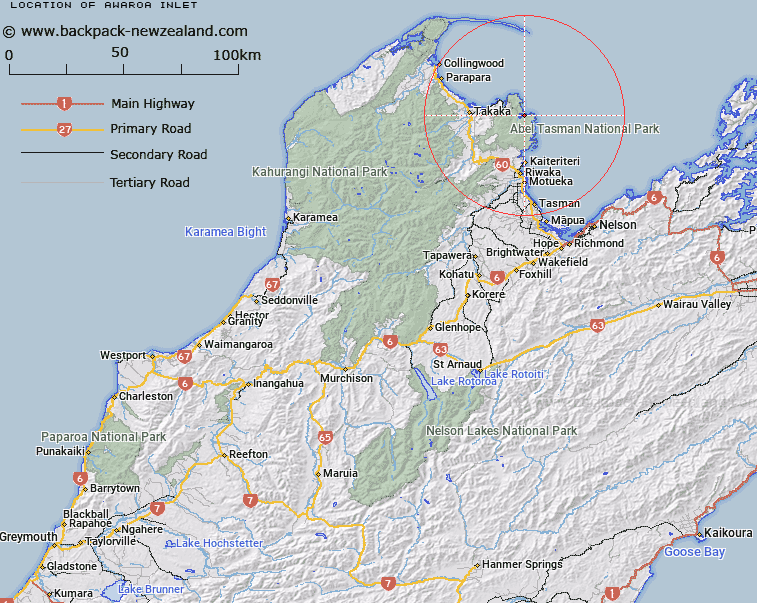
Map showing location of Awaroa Inlet


LINZ description: Feature shown on: NZMS260 N26 Edition 1 1986; Infomap 346-02 Te Wai Pounamu Edition 1 1995; NZTopo50-BP25 010765
Latitude: -40.862784
Longitude: 173.011628
Northing: 5476475
Easting: 1600980
Land District: Nelson
Feat Type: Bay


Scroll down to see a more detailed road map and below that a topographical map showing the location of Awaroa Inlet. The road map has been supplied by openstreetmap and the topographical map of Awaroa Inlet has been supplied by Land Information New Zealand (LINZ).

Yes you can use the top static map for you school/university project or personal website with a link back. Contact me for any commercial use.

Awaroa Inlet Map New Zealand


New Zealand places in our database
[ A ] [ B ] [ C ] [ D ] [ E ] [ F ] [ G ] [ H ] [ I ] [ J ] [ K ] [ L ] [ M ] [ N ] [ O ] [ P ] [ Q ] [ R ] [ S ] [ T ] [ U ] [ V ] [ W ] [ X ] [ Y ] [ Z ]


Closest 20 Bays to Awaroa Inlet

Awaroa Inlet ( 0km )   Waiharakeke Bay ( 1.77km )   Awaroa Bay ( 2.17km )   Goat Bay ( 3.01km )   Canoe Bay ( 3.2km )   Brereton Cove ( 3.95km )   Shag Harbour ( 4.43km )   Anapai Bay ( 6.71km )   Mosquito Bay ( 6.94km )   Bark Bay ( 7.31km )   Wainui Inlet ( 7.58km )   Takapou Bay ( 7.74km )   Anatakapau Bay ( 7.94km )   Sandfly Bay ( 8.02km )   Mutton Cove ( 8.41km )   Frenchman Bay ( 8.76km )   Wainui Bay ( 8.99km )   Whariwharangi Bay ( 9.36km )   Boundary Bay ( 9.44km )   R?kauroa / Torrent Bay ( 10.01km )   Torrent Bay ( 10.01km )   Ligar Bay ( 10.06km )   Tata Bay ( 10.23km )   Limestone Bay ( 10.67km )   The Anchorage ( 10.83km )   Te Pukatea Bay ( 11.01km )   Anchor Bay ( 11.63km )   Watering Cove ( 11.92km )   Cyathea Cove ( 12.24km )   Cyathees Cove ( 12.24km )   Akersten Bay ( 12.54km )   Stilwell Bay ( 12.73km )   Apple Tree Bay ( 13.54km )   Stream Cove ( 13.99km )   Coquille Bay ( 14.19km )   Tinline Bay ( 14.25km )   Sandy Bay ( 15.6km )   Ot?whero Inlet ( 16.83km )   Towers Bay ( 17.73km )   Ngaio Bay ( 18.13km )