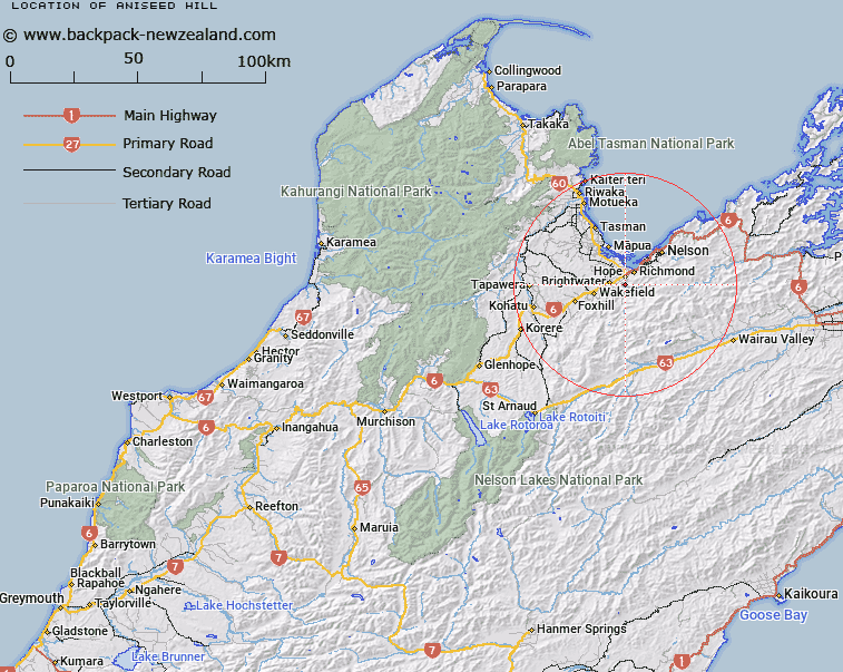
Map showing location of Aniseed Hill


LINZ description: Hill on Barnicoat Range, 4km south-west of Richmond Hill, Trig. Station Aniseed Hill (Geodetic Code B7UR) on summit. Waimea Survey District.
Latitude: -41.379581
Longitude: 173.15318
Northing: 5419093.1
Easting: 1612808.5
Land District: Nelson
Feat Type: Hill


Scroll down to see a more detailed road map and below that a topographical map showing the location of Aniseed Hill. The road map has been supplied by openstreetmap and the topographical map of Aniseed Hill has been supplied by Land Information New Zealand (LINZ).

Yes you can use the top static map for you school/university project or personal website with a link back. Contact me for any commercial use.

Aniseed Hill Map New Zealand


New Zealand places in our database
[ A ] [ B ] [ C ] [ D ] [ E ] [ F ] [ G ] [ H ] [ I ] [ J ] [ K ] [ L ] [ M ] [ N ] [ O ] [ P ] [ Q ] [ R ] [ S ] [ T ] [ U ] [ V ] [ W ] [ X ] [ Y ] [ Z ]


Closest 20 Hills to Aniseed Hill

Richmond Hill ( 3.98km )   Mount Heslington ( 4.13km )   Goat Hill ( 4.21km )   Rocky Knob ( 6.22km )   Saxton Hill ( 6.39km )   Clover Knob ( 7.56km )   Lucy Creek Knob ( 8.6km )   Mount Malita ( 10.01km )   Little Ben ( 11.09km )   Mount Meares ( 11.33km )   Jenkins Hill ( 11.92km )   Hacket Peaks ( 12.2km )   Mount Gale ( 12.68km )   Mount Starveall ( 12.68km )   Mount Stewart ( 12.95km )   Cut Hill ( 12.97km )   Grampians ( 13.93km )   Sugar Loaf ( 14.76km )   Blue Knob ( 14.95km )   Mount Claude ( 15.1km )   Fringed Hill ( 15.65km )   Slaty Peak ( 15.8km )   Pikimai / Church Hill ( 15.88km )   The Rocks ( 16.07km )   Bishops Cap ( 16.13km )   Sharland Hill ( 16.46km )   Purple Top ( 16.7km )   Wooded Peak ( 17km )   Botanical Hill ( 17.04km )   Mount Rintoul ( 17.11km )   Dun Mountain ( 19.05km )   K?k? Hill ( 19.2km )   Old Man ( 19.37km )   Ben Nevis ( 20.06km )   Grass Knob ( 20.47km )   Little Twin ( 20.64km )   Conical Knob ( 20.71km )   Mount Edelweiss ( 21.31km )   Wells Hill ( 22.11km )   Bushy Top ( 22.4km )