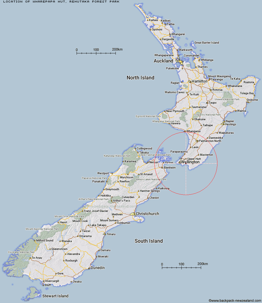
Topo Map showing location of Wharepapa Hut
This information is sourced from DoC, LINZ and Openstreetmap. Some of the hut photos are mine and the rest are from DoC. I will be adding an upload feature soon so people can photos of .Wharepapa Hut.
Basic info: basic five-bunk hut in the Wairarapa region.
Latitude: -41.3247212834
Longitude: 175.075433165
Location: Remutaka Forest Park
Area: Wairarapa
Type of Hut: Basic/bivvies
Map: BQ32 Topo Map | Road Map
Does this hut still exist? Have any more information? Contact
Basic info: basic five-bunk hut in the Wairarapa region.
Latitude: -41.3247212834
Longitude: 175.075433165
Location: Remutaka Forest Park
Area: Wairarapa
Type of Hut: Basic/bivvies
Map: BQ32 Topo Map | Road Map
Does this hut still exist? Have any more information? Contact
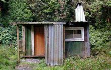
Image: DoC
Scroll down to see a topographical map and road map showing the location of Wharepapa Hut
[ A ] [ B ] [ C ] [ D ] [ E ] [ F ] [ G ] [ H ] [ I ] [ J ] [ K ] [ L ] [ M ] [ N ] [ O ] [ P ] [ Q ] [ R ] [ S ] [ T ] [ U ] [ V ] [ W ] [ Y ] [ Z ]
Closest 20 Huts to Wharepapa Hut
These are as the crow fliesPapatahi Hut 4.65km Haurangi Hut 6.55km Jans Hut 8km Waiorongomai Hut 8.01km Waerenga Hut 8.48km Boar Inn 9.15km Paua Hut 9.58km Barneys Whare 15.12km Tauanui Hut 20.41km Sutherlands Hut 24.7km Washpool Hut 24.8km Pararaki Hut 27.46km Kawakawa Hut 29.24km Mangatoetoe Hut 31.81km Smith Creek Shelter 34.52km Eastern Hutt Hut 37.69km Renata Hut 40.46km Tutuwai Hut 40.75km Elder Hut 41.38km Alpha Hut 41.47km Cone Hut 43.78km Waiotauru Hut 43.86km Waiohine Shelter 44.06km Kime Hut 45.53km Kapakapanui Hut 45.84km Field Hut 48.77km Neill Forks Hut 49.52km Sayer Hut 49.82km Penn Creek Hut 50.26km Maungahuka Hut 50.72km Totara Flats Hut 51.51km Aokaparangi Hut 53.73km Mid Waiohine Hut 56.3km Mountain House Shelter 56.38km Powell Hut 56.98km Anderson Memorial Hut 58.15km Waitewaewae Hut 58.21km Atiwhakatu Hut 59.86km Jumbo Hut 60.56km McGregor Bivouac 61.51km