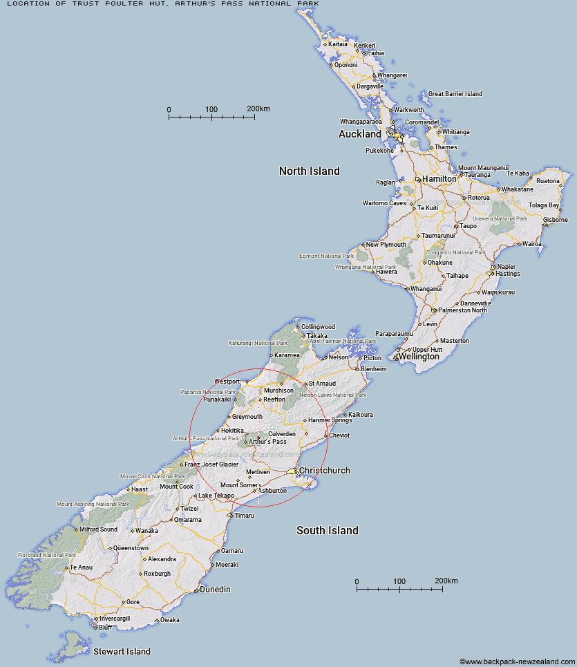
Topo Map showing location of Trust/Poulter Hut
This information is sourced from DoC, LINZ and Openstreetmap. Some of the hut photos are mine and the rest are from DoC. I will be adding an upload feature soon so people can photos of .Trust/Poulter Hut.
Basic info: standard six-bunk hut in the North Canterbury and Arthur's Pass area.
Latitude: -42.8547138631
Longitude: 171.842774385
Location: Arthur's Pass National Park
Area: Canterbury
Type of Hut: Standard
Tracks: Minchin Pass Route
Map: BV21 Topo Map | Road Map
Does this hut still exist? Have any more information? Contact
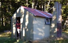
Image: DoC
Scroll down to see a topographical map and road map showing the location of Trust/Poulter Hut
[ A ] [ B ] [ C ] [ D ] [ E ] [ F ] [ G ] [ H ] [ I ] [ J ] [ K ] [ L ] [ M ] [ N ] [ O ] [ P ] [ Q ] [ R ] [ S ] [ T ] [ U ] [ V ] [ W ] [ Y ] [ Z ]
Closest 20 Huts to Trust/Poulter Hut
These are as the crow fliesPoulter Hut 2.74km Ranger Bivouac 4.38km Worsley Bivouac 4.88km Minchin Bivouac 7.18km Poulter Bivouac 7.32km East Hawdon Bivouac 7.4km Koropuku Hut 10.02km Townsend Hut 10.41km Otehake Hut 10.77km Hawdon Hut 10.94km Bull Creek Hut 11.09km Turnbull Bivouac 12.48km Locke Stream Hut 12.81km Kiwi Hut 13.57km Candlesticks Bivouac 15.02km Harper Pass Bivouac 15.08km Sudden Valley Bivouac 15.43km Upper South Branch Hurunui Hut 15.51km Pfeifer Bivouac 15.56km Andrews Shelter 16.01km Lochinvar Hut 16.07km Hawdon Shelter 16.7km Riversdale Hut 16.98km Top Trent / Lagoon Hut 17.25km Camerons Hut 18.32km Goat Pass Hut 18.51km Edwards Hut 18.59km Upper Deception Hut 18.69km Mid Trent Hut 18.84km Mingha Bivouac 18.92km Elizabeth Hut 19.11km North Esk Hut 19.47km Ant Stream Hut 20.6km Ant Stream Bivouac 20.7km Top Crooked Hut 20.8km Hurunui No 3 Hut 20.82km Cone Creek Hut 21.15km South Branch Research Hut 22.83km Anna Hut 23.37km Jacko Flat Hut 23.78km