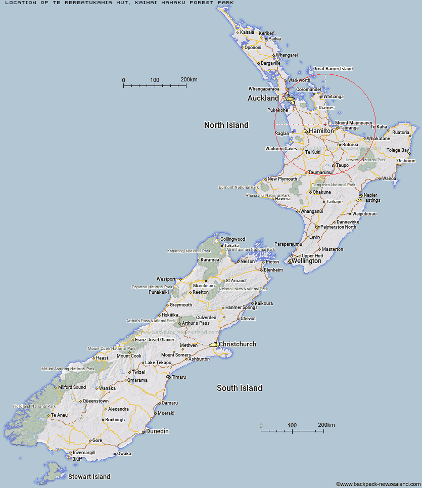
Topo Map showing location of Te Rereatukahia Hut
This information is sourced from DoC, LINZ and Openstreetmap. Some of the hut photos are mine and the rest are from DoC. I will be adding an upload feature soon so people can photos of .Te Rereatukahia Hut.
Basic info: standard 12-bunk hut in the Tauranga area.
Latitude: -37.5860680057
Longitude: 175.830614554
Location: Kaimai Mamaku Forest Park
Area: Bay of Plenty
Type of Hut: Standard
Tracks: Te Rereatukahia Loop Track|North-South Track
Map: BD35 Topo Map | Road Map
Does this hut still exist? Have any more information? Contact
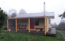
Image: DoC
Scroll down to see a topographical map and road map showing the location of Te Rereatukahia Hut
[ A ] [ B ] [ C ] [ D ] [ E ] [ F ] [ G ] [ H ] [ I ] [ J ] [ K ] [ L ] [ M ] [ N ] [ O ] [ P ] [ Q ] [ R ] [ S ] [ T ] [ U ] [ V ] [ W ] [ Y ] [ Z ]
Closest 20 Huts to Te Rereatukahia Hut
These are as the crow fliesMotutapere Hut 4.1km Wairoa Shelter 4.74km Waitawheta Hut 6.99km Kauritatahi Hut 9.19km Mangakino Shelter 10.66km Daly's Clearing Hut 12.77km Ngamuwahine Shelter 22.53km Mangamuka Hut 23.18km Hurunui Hut 27.13km Pinnacles Hut 61.39km Crosbies Hut 63.37km Pahautea Hut 79.15km Piggotts Hut 80.96km Wairua Hut 89.37km Wildlife Hut 94km Hamilton Tomo Group Hut 98.58km Bog Inn Hut 112.27km Waihua Hut 120.48km Mangamako Hut 122.15km Twain (Waipotiki) Hut 122.78km Saddle (Mangaawai) Hut 123.81km Casino Hut 124.46km Waihaha Hut 124.94km Apiti Hut 125.98km Duckville Hut 126.09km Horomanga Base Camp 126.61km Wharekahika Hut 128.82km Leitchs Hut 131.72km Ohora Hut 131.88km Hauhungaroa Hut 132.21km Manaohou Right Branch Hut 132.39km Okui Hut 134.04km Onepu Hut 135.7km Waikare Junction Hut 136.26km Hanamahihi Hut 136.3km Mangapouri Hut 137.28km Ongaruanuku Hut 138.43km Ohane Hut 138.89km Ngahiramai Hut 142.29km Takurua Hut 143.19km