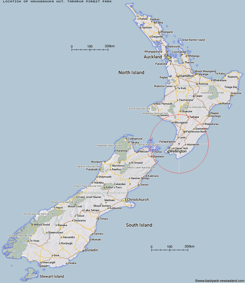
Topo Map showing location of Maungahuka Hut
This information is sourced from DoC, LINZ and Openstreetmap. Some of the hut photos are mine and the rest are from DoC. I will be adding an upload feature soon so people can photos of .Maungahuka Hut.
Basic info: standard 10-bunk hut in the Wairarapa region.
Latitude: -40.9122668594
Longitude: 175.333965039
Location: Tararua Forest Park
Area: Wairarapa
Type of Hut: Standard
Map: BP33 Topo Map | Road Map
Does this hut still exist? Have any more information? Contact
Basic info: standard 10-bunk hut in the Wairarapa region.
Latitude: -40.9122668594
Longitude: 175.333965039
Location: Tararua Forest Park
Area: Wairarapa
Type of Hut: Standard
Map: BP33 Topo Map | Road Map
Does this hut still exist? Have any more information? Contact
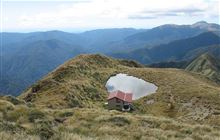
Image: DoC
Scroll down to see a topographical map and road map showing the location of Maungahuka Hut
[ A ] [ B ] [ C ] [ D ] [ E ] [ F ] [ G ] [ H ] [ I ] [ J ] [ K ] [ L ] [ M ] [ N ] [ O ] [ P ] [ Q ] [ R ] [ S ] [ T ] [ U ] [ V ] [ W ] [ Y ] [ Z ]
Closest 20 Huts to Maungahuka Hut
These are as the crow fliesNeill Forks Hut 2.94km Aokaparangi Hut 3.17km Penn Creek Hut 4.17km Mid Waiohine Hut 5.84km Kime Hut 6.24km Totara Flats Hut 6.24km Sayer Hut 6.33km Field Hut 6.55km Anderson Memorial Hut 7.55km Powell Hut 8.17km Cone Hut 8.39km Mountain House Shelter 8.44km Alpha Hut 9.27km Waitewaewae Hut 9.34km Elder Hut 10.8km Tutuwai Hut 10.91km McGregor Bivouac 10.96km Jumbo Hut 10.98km Atiwhakatu Hut 11.22km Waiohine Shelter 11.64km Nichols Hut 11.88km Waiotauru Hut 12.84km Eastern Hutt Hut 13.05km Mid King Bivouac 13.48km Dorset Ridge Hut 13.82km Carkeek Hut 14.55km Renata Hut 14.92km Kapakapanui Hut 15.01km Mitre Flats Hut 15.19km Tarn Ridge Hut 16km Smith Creek Shelter 16.47km Dracophyllum Hut 16.53km Arete Forks Hut 19.29km Cow Creek Hut 20.04km Arete Hut 20.16km Te Matawai Hut 20.18km Blue Range Hut 20.4km Waiopehu Hut 20.76km South Ohau Hut 22.11km Waikawa Shelter 22.51km