Topo Map showing location of Hope Halfway Hut
This information is sourced from DoC, LINZ and Openstreetmap. Some of the hut photos are mine and the rest are from DoC. I will be adding an upload feature soon so people can photos of .Hope Halfway Hut.
Basic info: basic six-bunk hut in the North Canterbury and Arthur's Pass area.
Latitude: -42.6157649295
Longitude: 172.297922756
Location: Lake Sumner Forest Park
Area: Canterbury
Type of Hut: Basic/bivvies
Tracks: Hurunui swingbridge tracks & routes
Map: BU23 Topo Map | Road Map
Does this hut still exist? Have any more information? Contact
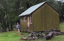
Image: DoC
Scroll down to see a topographical map and road map showing the location of Hope Halfway Hut

[ A ] [ B ] [ C ] [ D ] [ E ] [ F ] [ G ] [ H ] [ I ] [ J ] [ K ] [ L ] [ M ] [ N ] [ O ] [ P ] [ Q ] [ R ] [ S ] [ T ] [ U ] [ V ] [ W ] [ Y ] [ Z ]
Closest 20 Huts to Hope Halfway Hut
These are as the crow fliesHope Halfway Hut 0km Museum Hut 3.8km Saint Jacob's Hut 5.18km Bus Shelter 7.33km Evangeline Bivouac 7.58km Doubtful Hut 9.49km Lake Man Bivouac 9.52km Top Hope Hut 10.43km Gabriel Hut 11.75km Jollie Brook Hut 11.95km Doubtless Hut 11.97km Three Mile Stream Hut 12.52km Devils Den Bivouac 14.23km Glenrae Bivouac 14.74km Cold Stream Hut 15.83km Lake Sumner Hut 16.01km Upper Nina Bivouac 16.39km Nina Hut 16.79km Lake Mason Hut 17.45km Carlyle Hut 17.76km Top Robinson Hut 18.13km Slaty Creek Hut 19.14km Hurunui Hut 19.19km Mackenzie Bivouac 19.35km Magdalen Hut 19.59km Glenrae Hut 19.93km Lake Christabel Hut 20.17km Boyle Flat Hut 21.37km Lucretia Hut 21.38km Mid Robinson Hut 21.77km Brass Monkey Bivouac 21.88km Valley Camp Hut 22.01km Stony Stream Hut 22.22km South Branch Research Hut 22.94km Mackenzie Hut 23.15km Bush Hut 23.23km Bush Camp Hut 24.29km Rokeby Hut 24.38km Deep Creek Hut 24.64km Tutu Hut 26.28km