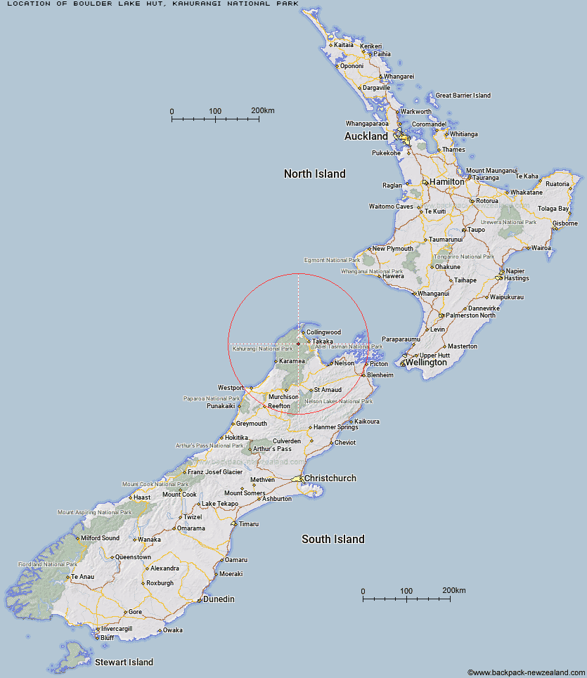
Topo Map showing location of Boulder Lake Hut
This information is sourced from DoC, LINZ and Openstreetmap. Some of the hut photos are mine and the rest are from DoC. I will be adding an upload feature soon so people can photos of .Boulder Lake Hut.
Basic info: standard 8-bunk hut in the Golden Bay area.
Latitude: -40.8999619516
Longitude: 172.578854005
Location: Kahurangi National Park
Area: Nelson/Tasman
Type of Hut: Standard
Tracks: Douglas Range
Map: BP24 Topo Map | Road Map
Does this hut still exist? Have any more information? Contact
Basic info: standard 8-bunk hut in the Golden Bay area.
Latitude: -40.8999619516
Longitude: 172.578854005
Location: Kahurangi National Park
Area: Nelson/Tasman
Type of Hut: Standard
Tracks: Douglas Range
Map: BP24 Topo Map | Road Map
Does this hut still exist? Have any more information? Contact
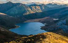
Image: DoC
Scroll down to see a topographical map and road map showing the location of Boulder Lake Hut
[ A ] [ B ] [ C ] [ D ] [ E ] [ F ] [ G ] [ H ] [ I ] [ J ] [ K ] [ L ] [ M ] [ N ] [ O ] [ P ] [ Q ] [ R ] [ S ] [ T ] [ U ] [ V ] [ W ] [ Y ] [ Z ]
Closest 20 Huts to Boulder Lake Hut
These are as the crow fliesAnatoki Forks Hut 5.02km Adelaide Tarn Hut 5.6km Lonely Lake Hut 9.36km Soper Shelter 11.92km Brown Hut 12.36km Perry Saddle Hut 14.79km Fenella Hut 17.24km Cobb Hut 17.92km Waingaro Forks Hut 18.06km Tent Camp 18.82km Gouland Downs Hut 18.99km Tin Hut Shelter 19.85km Riordans Hut 21.24km Chaffey Hut 21.68km Saxon Hut 22.8km Sylvester Hut 23.56km Trilobite Hut 25.73km Myttons Hut 26.47km Asbestos Cottage 27.25km Wainui Hut 28.74km Ministry of Works Historic Hut 29.06km Balloon Hut 30.15km Moa Park Shelter 30.32km James Mackay Hut 30.46km Awapoto Hut 30.54km Growler Rock Shelter 30.76km Dry Rock Shelter 31.63km Upper Gridiron Hut and Rock Shelters 31.68km Castle Rock Hut 32.24km Flora Hut 33.89km Splugeons Rock Shelter 34.05km Mt Arthur Hut 35.04km Roaring Lion Hut 35.3km Whariwharangi Hut 35.48km Holyoake Clearing Shelter 36.23km Lewis Hut 36.48km Awaroa Hut 37.08km Karamea Bend Hut 37.48km Ellis Hut 38.61km Bark Bay Hut 39.52km