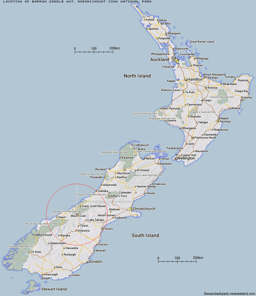
Topo Map showing location of Barron Saddle Hut
This information is sourced from DoC, LINZ and Openstreetmap. Some of the hut photos are mine and the rest are from DoC. I will be adding an upload feature soon so people can photos of .Barron Saddle Hut.
Basic info: This is an alpine serviced eight-bunk hut in the Aoraki/Mount Cook area.
Latitude: -43.7590037312
Longitude: 170.00047498
Location: Aoraki/Mount Cook National Park
Area: Canterbury
Type of Hut: Serviced Alpine
Map: BY15 Topo Map | Road Map
Does this hut still exist? Have any more information? Contact
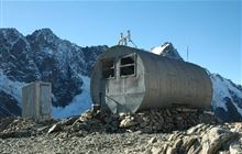
Image: DoC
Scroll down to see a topographical map and road map showing the location of Barron Saddle Hut
[ A ] [ B ] [ C ] [ D ] [ E ] [ F ] [ G ] [ H ] [ I ] [ J ] [ K ] [ L ] [ M ] [ N ] [ O ] [ P ] [ Q ] [ R ] [ S ] [ T ] [ U ] [ V ] [ W ] [ Y ] [ Z ]
Closest 20 Huts to Barron Saddle Hut
These are as the crow fliesReardon Hut 4.89km Harpers Rock Bivouac 6.12km Mueller Hut 6.7km Waterfall Hut 8.33km Christmas Flat Hut 8.67km Richardson Rock Bivouac 9.92km Sefton Bivvy 9.96km Horace Walker Hut 10.03km Stocking Stream Shelter 10.28km Douglas Rock Hut 11.87km Erceg Hut 11.92km Lame Duck Hut 12.2km Kennedy Hut 13.78km Copland Shelter 13.99km Welcome Flat Campsite 14.93km Welcome Flat Hut 14.95km Cassel Flat Hut 17.88km Dodger Hut 18.08km Architect Creek Hut 18.82km Jollie Hut 19.03km Caroline Hut 19.38km Green Point Hut 19.52km Grough Hut 19.87km Empress Hut 20.72km Ball Hut 21.38km Littles Hut 21.54km Whale Stream Hut 21.92km Cullers Hut 22.4km Elcho Hut 23.53km Station Hut 23.59km Plateau Hut 24.46km Haast Hut 25.16km Dasler Bivouac 25.19km Stony Stream Bivouac 27.57km Liebig Hut 28.83km Chancellor Hut 28.99km Maryburn Hut 29.03km Le Crens Hut 29.08km Pioneer Hut 29.26km Onslow Hut (Steffan Memorial Hut) 29.73km